West Lafayette in Tippecanoe County, Indiana — The American Midwest (Great Lakes)
Welcome to West Lafayette
Photographed by Craig Doda, September 13, 2026
1. Welcome to West Lafayette Marker
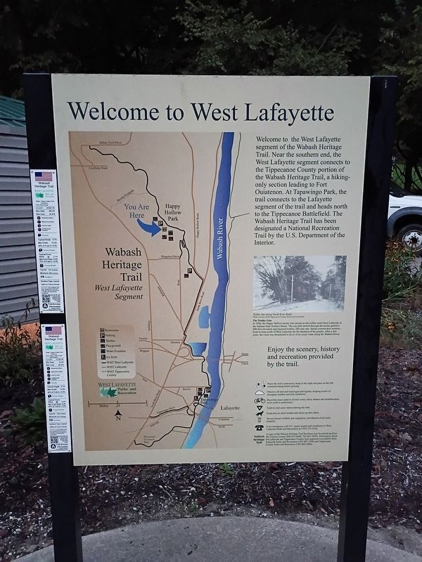
Welcome to the West Lafayette segment of the Wabash Heritage Trail. Near the southern end, the West Lafayette segment connects to the Tippecanoe County portion of the Wabash Heritage Trail, a hiking- only section leading to Fort Ouiatenon. At Tapawingo Park, the trail connects to the Lafayette segment of the trail and heads north to the Tippecanoe Battlefield. The Wabash Heritage Trail has been designated a National Recreation Trail by the U.S. Department of the Interior.
[Caption:]
The Trolley Line
In 1896, the Happy Hollow ravine was chosen as the trolley route from Lafayette to the Indiana State Soldiers Home. The one mile stretch through the ravine gained a 200-foot elevation and required trestles, fills and cuts. Italian construction workers lived in tents north of West Lafayette for the duration of the project. After a few years, the route was abandoned in favor of an easier route along the Wabash River.
Topics. This historical marker is listed in these topic lists: Parks & Recreational Areas • Railroads & Streetcars • Roads & Vehicles. A significant historical year for this entry is 1896.
Location. 40° 26.396′ N, 86° 54.176′ W.
this page online

Regionally, this marker is in Central Indiana. It is also in the American Midwest and in the Corn Belt. Globally, it is in North America, the Western Hemisphere, the Western World, and the Anglosphere. Historically, it finds itself in what was once the Viceroyalty of New France, the territory of the Mississippian Culture, and the Northwest Territory.
Other nearby markers. At least 8 other markers are within 2 miles of this marker, measured as the crow flies: In Memory of Our Civil War Soldiers (approx. one mile away); Lafayette Revolutionary War Memorial (approx. 1.1 miles away); William Henry Harrison Memorial Bridge (approx. 1.1 miles away); Dr. Elizur Deming (approx. 1.1 miles away); Pvt. Charles Felix Sr. 1863-1865 (approx. 1.2 miles away); Colonel William Carroll (approx. 1.2 miles
Photographed by Craig Doda, September 13, 2026
2. Welcome to West Lafayette Marker
Another marker is no longer nearby. The Wabash River (was approx. 0.4 miles away but has been permanently removed).
Credits. This page was last revised on October 23, 2026. It was originally submitted on October 21, 2026, by Craig Doda of Napoleon, Ohio. This page has been viewed 17 times since then. Photos: 1, 2. submitted on October 21, 2026, by Craig Doda of Napoleon, Ohio. • Devry Becker Jones was the editor who published this page.
