
Albert Park in Port Phillip, Victoria, Australia — Oceania
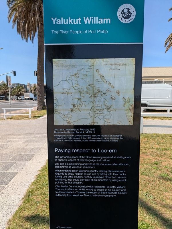
Paying Respect to Loo-ern
| — | Yalukut Willam - The River People of Port Phillip | — |
Photographed by Dean Barton-Ancliffe, September 29, 2026
1. Paying Respect to Loo-ern Marker
Loo-ern is a spirit being and lives in the mountain called Wamoon, also known as Wilsons Promontory.
When entering Boon Wurrung country, visiting clansmen were required to show respect to Loo-ern by sitting with their backs facing Loo-ern's country. As they journeyed closer to Loo-ern's residence, they could only look at his mountain by using a stick pointing in that direction.
Clan leader Derimut travelled with Aboriginal Protector William Thomas to Wamoon in the 1840's to check on his country and to demonstrate to Thomas the extent of Boon Wurrung country, extending from Werribee River to Wilsons Promontory.
Erected by City of Port Phillip. (Marker Number 11.)
Topics. This historical marker is listed in these topic lists: Exploration • Indigenous Peoples and Communities. A significant historical year for this entry is 1840.
Location. 37° 50.953′ S, 144° 57.066′ E. Marker is in Albert Park, Victoria, in Port Phillip. It is at the intersection of Beaconsfield Parade (Victoria Route 33) and
this page online

Regionally, it is in Oceania, in Australasia, in the Pacific Ocean, in South Pacific, on the Pacific Rim, in the Western World, and in the Anglosphere. Historically, it finds itself in what was once a British colony.
Other nearby markers. At least 8 other markers are within walking distance of this marker: Neptune (approx. 1.2 kilometers away); Answering the Call - Naval Heritage Foundation (approx. 1.2 kilometers away); Port Melbourne Foreshore (approx. 1.3 kilometers away); Sandridge Town Pier (approx. 1.3 kilometers away); Great War Drinking Fountain Memorial Port Melbourne (approx. 1.4 kilometers away); War Memorial Port Melbourne (approx. 1.4 kilometers away); The Liardet Memorial (approx. 1.4 kilometers away); The Sandridge Hotel (approx. 1.6 kilometers away).
Also see . . . Yalukut Willam - The River People of Port Phillip. Meyer Eidelson
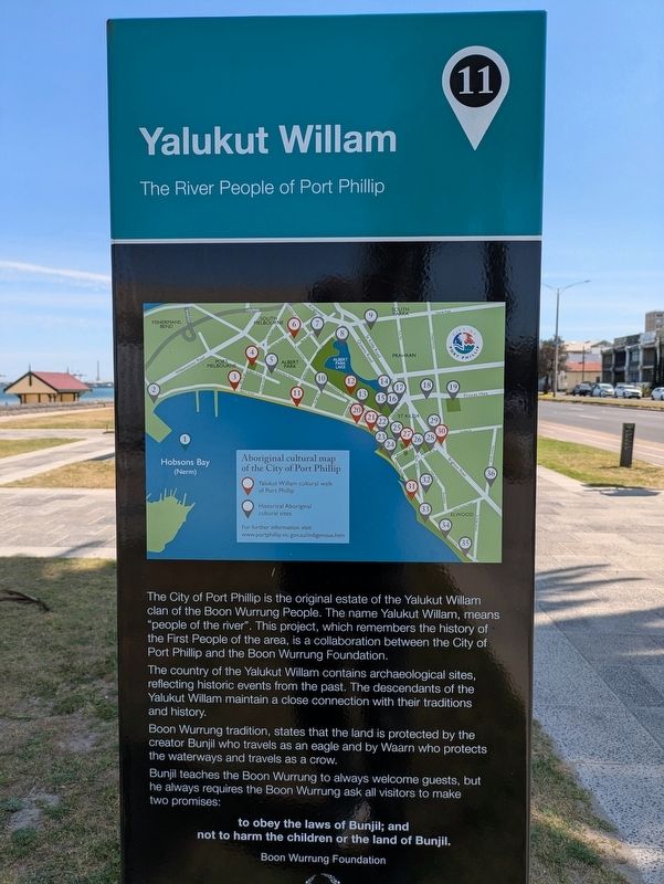
Before the arrival of Europeans in 1835, the City of Port Phillip area(Submitted on October 28, 2026, by Dean Barton-Ancliffe of Rowville, Victoria.)was occupied by the Yalukit Willam clan of the Boon Wurrung people or language group.Photographed by Dean Barton-Ancliffe, September 29, 20262. Paying Respect to Loo-ern Marker Reverse
Yalukit Willam means ‘river home’ or ‘people of the river’. This is an accurate description for a people whose territory was on a flood plain surrounded by water near the mouth of the Yarra River.
The City of Port Phillip landscape has changed vastly since European occupation but it was once a kind of ‘temperate Kakadu’ surrounded by sea, river, creeks, lakes and lagoons. To the west and north was the encircling Yarra River and estuary. To the south was the foreshore of Hobsons Bay, a crescent of coastline linking today’s Port Melbourne, St Kilda and South Melbourne. Between the sea and the river was a score of wetlands surrounded by dunes, heath, woodlands, salt marsh and beach, that teemed with wildfowl.
Waterways, in fact, defined the boundaries of most of Melbourne’s clans. Boon Wurrung lands were mainly those with streams that flowed to the sea. The Woiwurrung or Wurundjeri occupied lands drained by the tributaries of the Yarra and Maribyrnong Rivers.
Photographed by Dean Barton-Ancliffe, September 29, 2026
3. Paying Respect to Loo-ern Marker near the bay
Credits. This page was last revised on October 30, 2026. It was originally submitted on October 28, 2026, by Dean Barton-Ancliffe of Rowville, Victoria. This page has been viewed 13 times since then. Photos: 1, 2, 3. submitted on October 28, 2026, by Dean Barton-Ancliffe of Rowville, Victoria. • Andrew Ruppenstein was the editor who published this page.
