Saint-Bernard-de-Lacolle in Les Jardins-de-Napierville, Québec — Central Canada (French-Canadian)
Saint-Bernard-de-Lacolle Historique
Attraits patrimoniaux
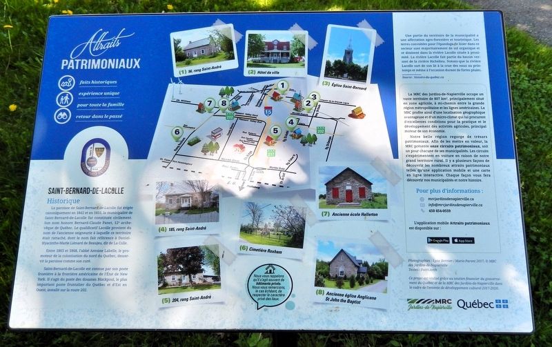
Photographed by Cosmos Mariner, May 19, 2024
1. Saint-Bernard-de-Lacolle Historique Marker

Entre 1863 et 1868, l'abbé Antoine Labelle, le promoteur de la colonisation du nord du Québec, desservit la paroisse comme son curé.
Saint-Bernard-de-Lacolle est connue par son poste frontière à la frontière américaine de l'État de New York. Il s'agit du poste des douanes Blackpool, le plus important poste frontalier du Québec et d'Est en Ouest, installé sur la route 202.
Une partie du territoire de la municipalité a une affectation agro-forestière et touristique. Les terres convoitées pour l'épandage de lisier dans ce secteur sont majoritairement de sol organique et se drainent dans la rivière Lacolle située à proximité. La rivière Lacolle fait partie du bassin versant de la rivière Richelieu. Notons que la
this page online
Source : histoire-du-quebec.ca
La MRC des Jardins-de-Napierville occupe un vaste territoire de 807 km2, principalement situé en zone agricole, à mi-chemin entre la grande région métropolitaine et les lignes américaines. La MRC profite ainsi d'une localisation géographique avantageuse et d'un micro-climat qui lui procurent d'excellentes conditions pour la pratique et le développement des activités agricoles, principal moteur de son économie.
Notre belle région regorge de trésors patrimoniaux. Afin de les mettre en valeur, la MRC présente onze circuits patrimoniaux, soit un pour chacune de ses municipalités. Les circuits s'expérimentent en voiture en raison de notre grand territoire rural. Il y a plusieurs façons de découvrir les nombreux attraits patrimoniaux telles qu'une application mobile et une carte en ligne interactive. Chaque façon vous fera découvrir nos municipalités et notre histoire.
Heritage Attractions
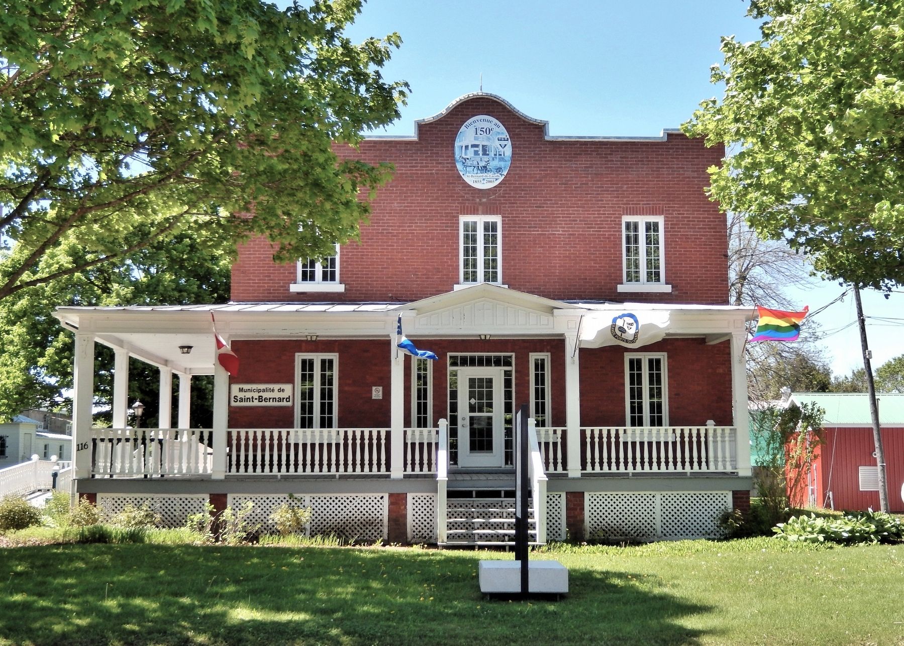
Photographed by Cosmos Mariner, May 19, 2024
2. Saint-Bernard-de-Lacolle City Hall
The marker is beside the sidewalk, just beyond this image to the left.
Between 1863 and 1868, Father Antoine Labelle, a promoter of colonization in northern Quebec, served the parish as its priest.
Saint-Bernard-de-Lacolle is known for its border crossing to the American state of New York. This is the Blackpool customs post, the most important border crossing in Quebec from East to West, located on Route 202.
Part of the municipality's territory is designated for agro-forestry and tourism. The lands targeted for manure spreading in this area are mostly organic soil and drain into the Lacolle River nearby. The Lacolle River is part of the Richelieu River watershed. It's worth noting that the Lacolle River overflows its banks during the spring melt and occasionally during heavy rains.
Source: histoire-du-quebec.ca
The MRC of Jardins-de-Napierville covers a vast area of 807 km2, mostly situated in an agricultural zone, halfway between the major metropolitan area and the U.S. border. This gives the MRC a great geographic location and a microclimate that provide excellent conditions for practicing and developing agricultural activities, which are the main driver of its economy.
Our beautiful region is full of heritage treasures. To showcase them, the MRC offers eleven heritage routes, one for each of its municipalities. The routes are best explored by car because of our large rural area. There are several ways to discover the many heritage attractions, such as a mobile app and an interactive online map. Each option will let you explore our municipalities and our history.
(1) 56, rang Saint-André • (2) Hôtel de ville • (3) Église Saint-Bernard • (4) 185, rang Saint-André • (5) 204, rang Saint-André • (6) Cimetière Roxham • (7) Ancienne école Hallerton • (8) Ancienne Église Anglicane St. John the Baptist
Erected by Government of Québec and MRC Jardins-de-Napierville.
Topics. This historical marker is listed in these topic lists: Agriculture • Religion & Religious Structures • Settlements & Settlers • Waterways & Vessels. A significant historical year for this entry is 1842.
Location. 45° 5.002′ N, 73° 24.741′ W. Marker is in Saint-Bernard-de-Lacolle, Québec, in Les Jardins-de-Napierville. It is on Rang Saint-Claude one kilometer south of Chemin de la Grande-Ligne, on the right when traveling south. The marker is beside the sidewalk in front of the Saint-Bernard-de-Lacolle City Hall. Touch for map. Marker is at or near this postal address: 116 Rang Saint-Claude, Saint-Bernard-de-Lacolle QC J0J 1V0, Canada. Touch for directions.

Regionally, this marker is in Central Canada. Globally, it is in North America, the Western Hemisphere, and the Western World. Historically, it finds itself in what was once a British colony, the Viceroyalty of New France, the Haudenosaunee (Iroquois) Confederacy, and Rupert’s Land.
Other nearby markers. At least 8 other markers are within 6 kilometers of this marker, measured as the crow flies: Église de Saint-Bernard Centenaire (within shouting distance of this marker); Église Notre-Dame-du-Mont-Carmel (approx. 3.1 kilometers away); Hôtel de ville de Lacolle (approx. 3.1 kilometers away); Lacolle War Memorial (approx. 3.1 kilometers away); L'Église Unie de Lacolle (approx. 3.1 kilometers away); La bataille du pont de Lacolle (approx. 3.2 kilometers away); La Bataille d’Odelltown / Battle of Odelltown (approx. 5 kilometers away); Bataille du Moulin de Lacolle / Battle of the Lacolle Mill (approx. 5.7 kilometers away).
Related markers. Click here for a list of markers that are related to this marker.
Credits. This page was last revised on November 8, 2026. It was originally submitted on November 4, 2026, by Cosmos Mariner of Cape Canaveral, Florida. This page has been viewed 9 times since then. Photos: 1, 2. submitted on November 8, 2026, by Cosmos Mariner of Cape Canaveral, Florida.
