Schuylerville in Saratoga County, New York — The American Northeast (Mid-Atlantic)
Lakes To Locks Passage
The Great Northeast Journey
| — | Champlain Canal Region | — |
Photographed by Steve Stoessel, November 7, 2026
1. Lakes To Locks Passage Marker
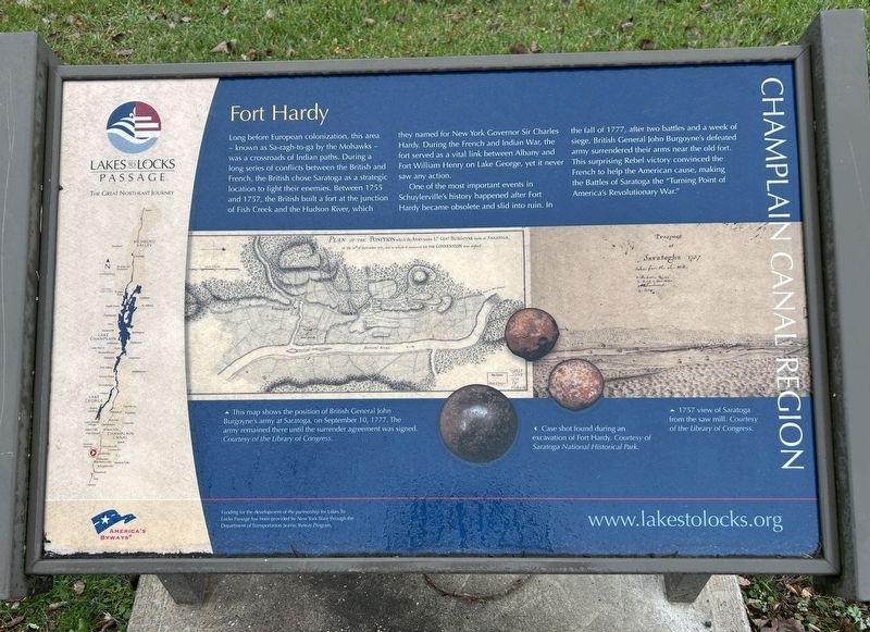
Fort Hardy
Long before European colonization, this area - known as Sa-ragh-to-ga by the Mohawks - was a crossroads of Indian paths. During a long series of conflicts between the British and French, the British chose Saratoga as a strategic location to fight their enemies. Between 1755 and 1757, the British built a fort at the junction of Fish Creek and the Hudson River, which they named for New York Governor Sir Charles Hardy. During the French and Indian War, the fort served as a vital link between Albany and Fort William Henry on Lake George, yet it never saw any action.
One of the most important events in Schuylerville's history happened after Fort Hardy became obsolete and slid into ruin. In the fall of 1777, after two battles and a week of siege, British General John Burgoyne's defeated army surrendered their arms near the old fort. This surprising Rebel victory convinced the French to help the American cause, making the Battles of Saratoga the "Turning Point of America's Revolutionary War."
Funding for the development of the partnership for Lakes To Locks Passage has been provided by New York State through
this page online
[ Illustration Captions: ]
• This map shows the position of British General John Burgoyne's army at Saratoga, on September 10, 1777. The army remained there until the surrender agreement was signed. Courtesy of the Library of Congress.
• Case shot found during an excavation of Fort Hardy. Courtesy of Saratoga National Historical Park.
• 1757 view of Saratoga from the saw mill. Courtesy of the Library of Congress.
Erected by Scrnic Byways.
Topics. This historical marker is listed in these topic lists: Indigenous Peoples and Communities • War, French and Indian • War, US Revolutionary. A significant historical year for this entry is 1755.
Location. 43° 6.009′ N, 73° 34.787′ W. Marker is in Schuylerville, New York, in Saratoga County. It is on Empire State Trail north of Ferry Street (New York State Route 29), on the right when traveling south. Touch for map. Marker is in this post office area: Schuylerville NY 12871, United States of America. Touch for directions.

Regionally, this marker is in Upstate New York, in the Capital District, and in the
Photographed by Steve Stoessel, November 7, 2026
2. Lakes To Locks Passage Marker
Other nearby markers. At least 8 other markers are within walking distance of this marker: Empire State Trail (here, next to this marker); Near This Spot (within shouting distance of this marker); The Fate Of The Defeated (within shouting distance of this marker); Who Was In An 18th Century Army (within shouting distance of this marker); An Army On The Move (within shouting distance of this marker); Henry Knox And The Noble Train Of Artillery (within shouting distance of this marker); First Bridge (within shouting distance of this marker); America’s Turning Point (within shouting distance of this marker). Touch for a list and map of all markers in Schuylerville.
Credits. This page was last revised on November 10, 2026. It was originally submitted on November 10, 2026, by Steve Stoessel of Niskayuna, New York. This page has been viewed 3 times since then. Photos: 1, 2. submitted on November 10, 2026, by Steve Stoessel of Niskayuna, New York.
