
King's Lynn in Norfolk, England, United Kingdom — Northwestern Europe (the British Isles)
St James' Park
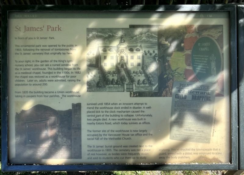
Photographed by Ray Gurganus, April 29, 2026
1. St James' Park Marker
This ornamental park was opened to the public in 1903, following the removal of tombstones from the St James' cemetery that originally lay here.
To your right, in the garden of the King's Lynn nursery school, you can see a ruined window from the St James' workhouse. This building began its life as a medieval chapel, founded in the 1100s. In 1682 the chapel was restored as a workhouse for poor. children. Later on, adults were admitted, raising the population to around 200.
From 1835 the building became a Union workhouse, taking in paupers from four parishes. The workhouse survived until 1854 when an innocent attempt to mend the workhouse clock ended in disaster. A well- placed kick to the clock mechanism caused the central part of the building to collapse. Unfortunately, two people died. A new workhouse was built in nearby Extons Road, which today survives as offices.
The former site of the workhouse is now largely occupied by the Vancouver House tax office and the social hall of the Methodist Church.
The St James' burial ground was created next to the workhouse in 1805.
this page online
Erected by Borough Council of King's Lynn & West Norfolk.
Topics. This historical marker is listed in these topic lists: Cemeteries & Burial Sites • Parks & Recreational Areas. A significant historical year for this entry is 1903.
Location. 52° 45.1′ N, 0° 24.034′ E. Marker is in King's Lynn, England, in Norfolk. It is on St James’ Road north of County Court Road, on the left when traveling south. Touch for map. Marker is in this post office area: King's Lynn, England PE30 5ER, United Kingdom. Touch for directions.

Regionally, this marker is in East Anglia. Globally, it is on the Atlantic Ocean, in the North Atlantic Region, in Europe, in Atlantic Europe, on one of the British Isles, in the Western World, and in the Anglosphere. Historically, it finds itself in what was once the Roman Empire and also the Hanseatic League.
Other nearby markers. At least 8 other markers are within walking distance of this marker: St James' Chapel (a few steps from this marker); Exploring Greyfriars Tower (within shouting distance of this marker); Tower Gardens (about 90 meters away, measured in a direct line); King's Lynn Greyfriars 1538 (about 90 meters away); Greyfriars Tower (about 90 meters away); Greyfriars, King's Lynn (about 120 meters away); a different marker also named St James' Park (about 150 meters away); All Saints Church (about 240 meters away). Touch for a list and map of all markers in King's Lynn.
Credits. This page was last revised on November 14, 2026. It was originally submitted on November 12, 2026, by Ray Gurganus of Washington, District of Columbia. This page has been viewed 9 times since then. Photo 1. submitted on November 12, 2026, by Ray Gurganus of Washington, District of Columbia. • Andrew Ruppenstein was the editor who published this page.
Editor’s want-list for this marker. photo of the marker within its surroundings • Can you help?
