
Frankfurt-Süd in Frankfurt am Main, Hesse, Germany — Central Europe
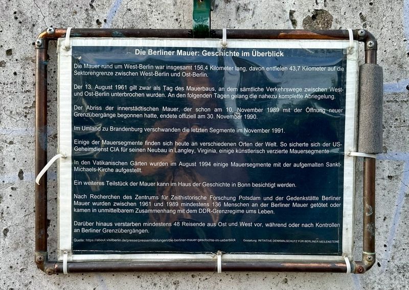
Die Berliner Mauer: Geschichte im Überblick
⎯⎯⎯
The Berlin Wall: Historical Overview
Photographed by Andrew Ruppenstein, October 16, 2026
1. Die Berliner Mauer: Geschichte im Überblick / The Berlin Wall: Historical Overview Marker

Die Mauer rund um West-Berlin war insgesamt 156,4 Kilometer lang, davon entfielen 43,7 Kilometer auf die Sektorengrenze zwischen West-Berlin und Ost-Berlin.
Der 13. August 1961 gilt zwar als Tag des Mauerbaus, an dem sämtliche Verkehrswege zwischen West- und Ost-Berlin unterbrochen wurden. An den folgenden Tagen gelang die nahezu komplette Abriegelung.
Der Abriss der innerstädtischen Mauer, der schon am 10. November 1989 mit der Öffnung neuer Grenzübergänge begonnen hatte, endete offiziell am 30. November 1990.
Im Umland zu Brandenburg verschwanden die letzten Segmente im November 1991.
Einige der Mauersegmente finden sich heute an verschiedenen Orten der Welt. So sicherte sich der US-Geheimdienst CIA für seinen Neubau in Langley, Virginia, einige künstlerisch verzierte Mauersegmente.
In den Vatikanischen Gärten wurden im August 1994 einige Mauersegmente mit der aufgemalten Sankt-Michaels-Kirche aufgestellt.
Ein weiteres Teilstück der Mauer kann im Haus der Geschichte in Bonn besichtigt werden.
Nach Recherchen des Zentrums für Zeithistorische Forschung
this page online
Darüber hinaus verstarben mindestens 48 Reisende aus Ost und West vor, während oder nach Kontrollen an Berliner Grenzübergängen.
Quelle: https://about visitberlin.de/presse/pressemitteilungen/die-berliner-mauer-geschichte-im-ueberblick
Gestaltung: INITIATIVE DENKMALSCHUTZ FOR BERLINER MEILENSTEINE
(English translation:)
The Berlin Wall: Historical Overview
The wall surrounding West Berlin had a total length of 156.4 kilometers, 43.7 kilometers of which made up the sectoral boundary between West Berlin and East Berlin.
Although August 13, 1961, is considered the day the Wall was built—marking the point when all transport links between West and East Berlin were severed—the near-complete sealing off of the city was achieved over the days that followed.
The demolition of the inner-city wall—which had already begun on November 10, 1989, with the opening of new border crossings—officially concluded on November 30, 1990.
In

Photographed by Andrew Ruppenstein, October 16, 2026
2. Berlin Wall and marker
Today, some of these wall segments can be found in various locations around the world. For instance, the U.S. Central Intelligence Agency (CIA) acquired several artistically decorated segments for its new headquarters in Langley, Virginia.
In August 1994, a number of wall segments—featuring a painting of St. Michael’s Church—were installed in the Vatican Gardens.
Another section of the Wall can be viewed at the Haus der Geschichte (House of the History of the Federal Republic of Germany) in Bonn.
According to research conducted by the Centre for Contemporary History in Potsdam and the Berlin Wall Memorial, at least 136 people were killed at the Berlin Wall—or lost their lives in direct connection with the GDR border regime—between 1961 and 1989.
Furthermore, at least 48 travelers from both East and West died before, during, or after undergoing checks at Berlin’s border crossings.
Source: https://about.visitberlin.de/presse/pressemitteilungen/die-berliner-mauer-geschichte-im-ueberblick
Design: INITIATIVE DENKMALSCHUTZ FÜR BERLINER MEILENSTEINE (“Initiative for the Preservation of Berlin Milestones”)
Topics and series.
Photographed by Andrew Ruppenstein, October 16, 2026
3. The Berlin Wall: Historical Overview Marker - wider view
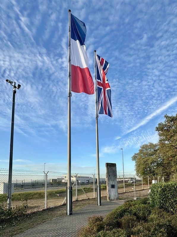
The Wall piece and marker are located in the north rear corner of the Berlin Luftbrückendenkmal (“Berlin Airlift Memorial”).
Location. 50° 2.287′ N, 8° 35.734′ E. Marker is in Frankfurt am Main, Hessen (Hesse). It is in Frankfurt-Süd. It can be reached from Ellis Road. The Wall segment and marker are located on the grounds of the Frankfurt Airport at the Luftbrückendenkmal (Berlin Airlift Memorial). It isn’t actually accessible from the airport, however. The Memorial can be reached either by driving to the nearby town of Zeppelinheim and parking in the informal parking area on Kirchneise/Flughafenstraße, or taking the S-Bahn to the Zeppelinheim stop. Either way, one still needs then to walk about about 300 meters east and go over the A5 Autobahn pedestrian overpass to reach the Memorial, which closes before sunset. Touch for map. Marker is in this post office area: Frankfurt am Main HE 60549, Germany. Touch for directions.

Regionally, it is in Europe, the European Union, Atlantic Europe, Central Europe, the Schengen Area, Western Europe, and the Western World. Historically, it finds itself in what was once the Roman Empire, the Holy Roman Empire, and the former West Germany.
Other nearby markers. At least 8 other markers are within 10 kilometers of this marker, measured as the crow flies: Die Siedlung Zeppelinheim / The Zeppelinheim Settlement (approx. 1.4 kilometers away); Zeppelin-Museum Zeppelinheim (approx. 1.4 kilometers away); a different marker also named Zeppelin-Museum Zeppelinheim (approx. 1.4 kilometers away); Mörfelden Synagoge (approx. 7.3 kilometers away); Die Industriegewerkschaft Chemie-Papier-Keramik / The Chemical-Paper-Ceramics Industrial Union (approx. 8.1 kilometers away); Prüfamt E-Werk / Power Station (approx. 8.6 kilometers away); Gutleutkaserne / Gutleut Barracks (approx. 8.6 kilometers away); Oskar Schindler (approx. 9.1 kilometers away). Touch for a list and map of all markers in Frankfurt am Main.
Credits. This page was last revised on November 21, 2026. It was originally submitted on November 20, 2026, by Andrew Ruppenstein of Lamorinda, California. This page has been viewed 3 times since then. Photos: 1, 2, 3. submitted on November 20, 2026, by Andrew Ruppenstein of Lamorinda, California.
