Near Bartow in Pocahontas County, West Virginia — The American South (Appalachia)
Staunton-Parkersburg Turnpike
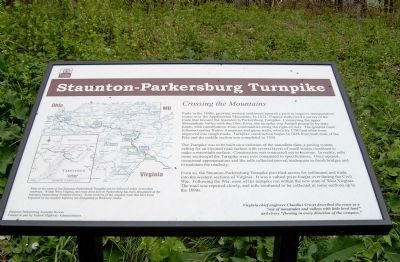
Crossing the Mountains
The Turnpike was to be built on a variation of the macadam plan, a paving system calling for an elevated road surface with several layers of small stones combined to make a watertight surface. Construction was contracted out in sections. In reality, only some sections of the Turnpike were ever completed to specifications. Once opened, occasional appropriations and the tolls collected proved inadequate to finish bridges and to maintain the roadway.
Even so, the Staunton-Parkersburg Turnpike provided access for settlement and trade into the western sections of Virginia. It was a valued prize fought over during the Civil War. Following the War, most of the turnpike ran within the new state of West Virginia. The road was repaired slowly, and tolls continued to be collected in some sections up to the 1890s.
Virginia chief engineer, Claudius Crozet described the route as a "sea of mountains and valleys with little level land" and rivers "flowing in every direction of the compass."
Most of the route of the Staunton-Parkersburg Turnpike can be followed today on modern roadways. Within West Virginia, the route from here to Parkersburg has been designated as the Staunton-Parkersburg Turnpike Byway. Some sections of the original route that have been bypassed by the modern highway are designated as Backway routes.
Erected by Staunton-Parkersburg Turnpike Byway (funded in part by Federal Highway Admnistration).
Topics. This historical marker is listed in these topic lists: Roads & Vehicles • War, US Civil. A significant historical year for this entry is 1822.
Location. Marker is missing. It was located near 38° 28.529′ N, 79° 41.948′ W. Marker was near Bartow, West Virginia, in Pocahontas County. Marker was at the intersection of U.S. 250 and Forest Service Road, on the right when traveling south on U.S. 250. Touch for map. Marker was in this post office area: Bartow WV 24920, United States of America. Touch for directions.
Other nearby markers. At least 8 other markers are within 2 miles of this location, measured as the crow flies. The First Campaign (here, next to this marker); The Great Raid (here, next to this marker); War In West Virginia (a few steps from this marker); Camp Allegheny (a few steps from this marker); West Virginia / Virginia (a few steps from this marker); Highland County / West Virginia (within shouting distance of this marker in Virginia); a different marker also named Camp Allegheny (approx. 0.7 miles away in Virginia); Camp Allegheny 1861-1862 (approx. 1.3 miles away). Touch for a list and map of all markers in Bartow.
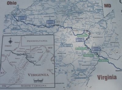
More about this marker. On the left side of the marker is a map of the turnpike indicating landmarks in West Virginia.
Also see . . . The Staunton-Parkersburg Turnpike Alliance. The alliance website offers details of the historic turnpike. (Submitted on July 11, 2010, by Craig Swain of Leesburg, Virginia.)
Credits. This page was last revised on June 9, 2020. It was originally submitted on July 11, 2010, by Linda Walcroft of Woodstock, Virginia. This page has been viewed 1,642 times since then and 60 times this year. Photos: 1. submitted on July 11, 2010, by Linda Walcroft of Woodstock, Virginia. 2, 3, 4. submitted on July 11, 2010, by Craig Swain of Leesburg, Virginia. • Craig Swain was the editor who published this page.


