Near Preston in Caroline County, Maryland — The American Northeast (Mid-Atlantic)
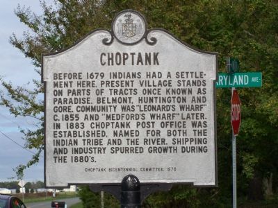
Choptank
Erected 1976 by Choptank Bicentennial Committee.
Topics. This historical marker is listed in these topic lists: Colonial Era • Native Americans • Political Subdivisions • Waterways & Vessels. A significant historical year for this entry is 1679.
Location. 38° 40.954′ N, 75° 57.068′ W. Marker is near Preston, Maryland, in Caroline County. Marker is at the intersection of Choptank Road and Maryland Ave., on the left when traveling south on Choptank Road. Touch for map. Marker is in this post office area: Preston MD 21655, United States of America. Touch for directions.
Other nearby markers. At least 8 other markers are within 4 miles of this marker, measured as the crow flies. The Maryland Lot (within shouting distance of this marker); Choptank Landing (about 400 feet away, measured in a direct line); Escape from Poplar Neck (about 400 feet away); Mt. Pleasant Cemetery (approx. 3 miles away); Mt. Pleasant M. E. Church (approx. 3 miles away); Preston (approx. 3.1 miles away); Freedom (approx. 3.1 miles away); Site of Frazier’s Chapel (approx. 3.1 miles away). Touch for a list and map of all markers in Preston.
Credits. This page was last revised on June 16, 2016. It was originally submitted on November 6, 2007, by Bill Pfingsten of Bel Air, Maryland. This page has been viewed 1,729 times since then and 50 times this year. Photos: 1, 2. submitted on November 6, 2007, by Bill Pfingsten of Bel Air, Maryland.

