Wythe in Hampton, Virginia — The American South (Mid-Atlantic)
Fertile Hunting Grounds For The Indians
Olde Wythe’s History Begins
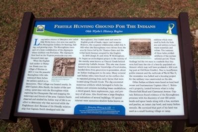
When the English laid anchor in Hampton Roads near the village of Kicotan in 1607, it was the peaceful Kecoughtan tribe who welcomed them before the settlers sailed on to Jamestown. Their village was located nearby. In 1608 Captain John Smith, the leader of the new colony, spent time with the Kecoughtan while exploring the Chesapeake Bay and mapping the waterways and forests of the area. Captain Smith observed and studied the Indian way of life in an effort to determine why they survived while the Englishmen died. Because of the friendly relationship that Captain Smith developed with the Kecoughtans, they traded meat and corn for English goods of beads, copper and weapons. However, the congenial relationship ended July 9, 1610 when the Kecoughtans were driven from the area by forces led by Sir Thomas Gates and the tribal lands became occupied by the English.
In 1940 Joseph B. and Alvin W. Brittingham, Sr. began an archeological project in the vicinity of the marshy area known as Church Creek behind present-day LaSalle Avenue. This site was chosen based on the excavators’ knowledge of local stories, handed down from generation to generation, about an Indian trading post in the area. Many colonial and Indian relics were found on the surface due to repeated plowing from early farms that were located along Church Creek. The dig uncovered numerous artifacts which belonged to both the Indians and colonists including brass candelabras, a sword guard, farm implements, jugs, and pottery of all sizes. Also found was a large fireplace and indications of several buildings. Of special interest were numerous shallow holes known as middons which were used by both the Indians and settlers to bury waste materials and refuse. The contents of these holes yielded artifacts of the earliest colonial period. These findings led the two men to conclude that this area had been the site of a heavily populated settlement which may well have predated a 1610 trading post at Old Point Comfort. Due to insufficient public interest and the outbreak of World War II, the excavation was halted and a housing project for the military was constructed on the site.
Other Indian artifacts were found on local land owner and businessman Captain John C. Robinson’s property, located between what is today Chesterfield Road and Claremont Avenue . Captain Robinson found evidence of the Kecoughtans presence with his discovery of over 150 arrowheads and spear heads along with a hoe, mortars and pestles, an intact clay bowl, and many Indian utensils. He surmised that part of his land was used as a small hunting village or camp.
Bringing History to Life
For more neighborhood information visit: www.oldewythe.com
For more visitor information visit: www.VisitHampton.com
In partnership with Virginia Civil War Trails, www.civilwartrails.org
Erected by Olde Wythe Neighborhood Association.
Topics. This historical marker is listed in these topic lists: Anthropology & Archaeology • Colonial Era • Exploration • Native Americans • Settlements & Settlers. A significant historical date for this entry is July 9, 1610.
Location. 37° 0.128′ N, 76° 21.767′ W. Marker is in Hampton, Virginia. It is in Wythe. Marker is at the intersection of Chesapeake Avenue (Virginia Route 167) and Cherokee Road, on the left when traveling south on Chesapeake Avenue. Touch for map. Marker is in this post office area: Hampton VA 23661, United States of America. Touch for directions.
Other nearby markers. At least 8 other markers are within walking distance of this marker. The Development Of Olde Wythe (about 500 feet away, measured in a direct line); Stalemate in Hampton Roads (about 500 feet away); First Battle of Ironclads (about 500 feet away); Olde Wythe During Colonial Times (approx. 0.2 miles away); Admiral Sir George Cockburn on the Chesapeake / The War of 1812 (approx. ¼ mile away); First Church at Kecoughtan (approx. ¼ mile away); Hampton Roads – World’s Greatest Harbor (approx. ¼ mile away); The Hampton Roads Golf And Country Club (approx. 0.4 miles away). Touch for a list and map of all markers in Hampton.
More about this marker. On the left is a "1590 engraving by Theodore deBry depicting a typical Algonquin Indian village" and on the upper right is a "1590 engraving by Theodore deBry illustrating Indian fishing techniques"
Also see . . .
1. Olde Wythe Neighborhood Association. (Submitted on August 2, 2010, by Bernard Fisher of Richmond, Virginia.)
2. Memories and History of Hampton Virginia’s Olde Wythe Neighborhood. (Submitted on August 2, 2010, by Bernard Fisher of Richmond, Virginia.)
3. Hampton Convention & Visitor Bureau. (Submitted on August 2, 2010, by Bernard Fisher of Richmond, Virginia.)
4. Virginia Civil War Trails. (Submitted on August 2, 2010, by Bernard Fisher of Richmond, Virginia.)
Credits. This page was last revised on February 1, 2023. It was originally submitted on August 2, 2010, by Bernard Fisher of Richmond, Virginia. This page has been viewed 1,559 times since then and 64 times this year. Photos: 1, 2. submitted on August 2, 2010, by Bernard Fisher of Richmond, Virginia. 3. submitted on October 4, 2010, by Bill Coughlin of Woodland Park, New Jersey.


