Wythe in Hampton, Virginia — The American South (Mid-Atlantic)
Olde Wythe During Colonial Times
Building Blocks for the Future
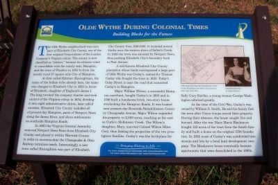
At first called Kikotan (Kecoughtan), the name of the Indian tribe already here, the name was changed to Elizabeth City in 1620 in honor of Elizabeth, daughter of England’s James I. The king revoked the company charter and took control of the Virginia colony in 1634, dividing it into eight administrative shires, later called counties. Elizabeth City County included all of present-day Hampton, parts of Newport News along the James River, and shore settlements on southside Hampton Roads.
In 1882 the Virginia General Assembly removed Newport News Point from Elizabeth City County and placed it within Warwick County in order to accommodate the Chesapeake & Ohio Railway terminus needs. Interestingly, a new town called Kecoughtan was part of Elizabeth City County from 1916-1926. It included several blocks near the eastern shore of Salter’s Creek. In 1926 the town was annexed by Newport News, thus pushing Elizabeth City’s boundary back to Pear Avenue.
A well-known Elizabeth City County plantation whose lands encompassed a large part of Olde Wythe was Ceeley’s, named for Thomas Ceeley who bought the tract in 1625. Today’s Celey Street is near the road that connected Ceeley’s to Hampton.
Major William Wilson, a successful Hampton merchant, bought Ceeley’s in 1695 and in 1706 built a handsome brick, two-story house overlooking the Hampton Roads. It was located near present-day Riverside Rehabilitation Center on Chesapeake Avenue. Major Wilson expanded his property to 2,000 acres, reaching as far east as Curle’s (Robinson) Creek. The Wilson’s daughter, Mary, married Colonel Wilson Miles Cary, thus linking the properties of the two prestigious families. Ceeley’s was the birthplace for Sally Cary Fairfax, a young woman George Washington admired greatly.
At the time of the Civil War, Ceeley’s was owned by William S. Smith. He and his family fled the area after Union troops seized their property. During their absence, the house caught fire and burned. After the war Mary Marie Blackmore bought 132 acres of the tract from the Smith family and built a home on the original 1706 foundation. In 1892 most of Ceeley’s was subdivided into streets and lots by a local land development company. The Blackmore house eventually became apartments that were demolished in the 1960s.
Bringing History to Life
For more neighborhood information visit: www.oldewythe.com
For more visitor information visit: www.VisitHampton.com
In partnership with Virginia Civil War Trails, www.civilwartrails.org
Erected by Olde Wythe Neighborhood Association.
Topics. This historical marker is listed in these topic lists: Colonial Era • Railroads & Streetcars • Settlements & Settlers • War, US Civil. A significant historical year for this entry is 1952.
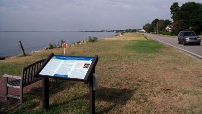
Location. 37° 0.075′ N, 76° 21.954′ W. Marker is in Hampton, Virginia. It is in Wythe. Marker is at the intersection of Chesapeake Avenue (Virginia Route 167) and Shenandoah Road, on the left when traveling south on Chesapeake Avenue. Touch for map. Marker is at or near this postal address: 3215 Chesapeake Avenue, Hampton VA 23661, United States of America. Touch for directions.
Other nearby markers. At least 8 other markers are within walking distance of this marker. The Development Of Olde Wythe (about 500 feet away, measured in a direct line); Admiral Sir George Cockburn on the Chesapeake / The War of 1812 (about 500 feet away); Hampton Roads – World’s Greatest Harbor (about 500 feet away); Fertile Hunting Grounds For The Indians (approx. 0.2 miles away); The Hampton Roads Golf And Country Club (approx. 0.2 miles away); Stalemate in Hampton Roads (approx. ¼ mile away); First Battle of Ironclads (approx. 0.3 miles away); Indian River Park – In The Heart Of Olde Wythe (approx. 0.4 miles away). Touch for a list and map of all markers in Hampton.
More about this marker. On the upper right is an "Undated portrait of Sally Fairfax" and an "1870 map showing the boundaries of the Ceely Plantation and other land owners after the Civil War."
Also see . . .
1. Memories and History of Hampton Virginia’s Olde Wythe Neighborhood. (Submitted on August 2, 2010, by Bernard Fisher of Richmond, Virginia.)
2. Hampton Convention & Visitor Bureau. (Submitted on August 2, 2010, by Bernard Fisher of Richmond, Virginia.)
3. Virginia Civil War Trails. (Submitted on August 2, 2010, by Bernard Fisher of Richmond, Virginia.)
Credits. This page was last revised on February 1, 2023. It was originally submitted on August 2, 2010, by Bernard Fisher of Richmond, Virginia. This page has been viewed 1,457 times since then and 50 times this year. Photos: 1, 2. submitted on August 2, 2010, by Bernard Fisher of Richmond, Virginia.

