Temecula in Riverside County, California — The American West (Pacific Coastal)
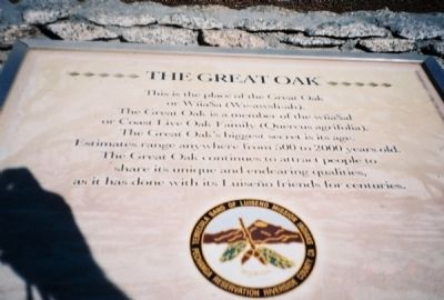
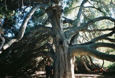
The Great Oak
Erected by The Pechanga Band (tribe) of Luiseno Indians.
Topics. This historical marker is listed in these topic lists: Environment • Horticulture & Forestry • Native Americans. A significant historical year for this entry is 2000.
Location. 33° 26.502′ N, 117° 5.559′ W. Marker is in Temecula, California, in Riverside County. 3.8 mi from I15 and Temecula Parkway Junction. .7 mi south from Temecula Parkway, 2.7 mi south on Pechanga Parkway (SR 79)/ Pala Road (S16). Left/east on Pechanga Road, .7 mi. Right/south, Tribal Governance Center, check at reception desk. Touch for map. Marker is in this post office area: Temecula CA 92590, United States of America. Touch for directions.
Other nearby markers. At least 8 other markers are within 7 miles of this marker, measured as the crow flies. Patricia H. Birdsall (approx. 0.8 miles away); The Wolf Store (approx. 2.6 miles away); Treaty of Temecula (approx. 2.6 miles away); Heart o' the Hills (approx. 4.7 miles away); First National Bank (approx. 4.8 miles away); Mission San Antonio de Pala (approx. 5.4 miles away); La Asistencia de San Antonio de Pala (approx. 5½ miles away); Dripping Springs Watering Hole (approx. 6.3 miles away). Touch for a list and map of all markers in Temecula.
More about this marker. To visit the marker and The Great Oak, visitors must get permission and a guide from the Pechanga Band. Road directions are to the Tribal Governance Center. It is advisable to call the Tribe well ahead, (some weeks) of time to get permission to visit
Credits. This page was last revised on November 16, 2020. It was originally submitted on September 27, 2010. This page has been viewed 1,729 times since then and 80 times this year. Photos: 1, 2. submitted on September 27, 2010. • Syd Whittle was the editor who published this page.

