Near Hite in Spokane County, Washington — The American West (Northwest)
Colville - Walla Walla Road
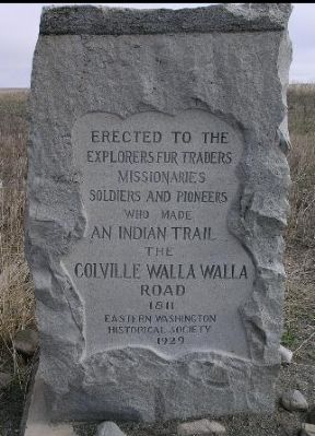
April 18, 2005
1. Colville - Walla Walla Road Marker
Explorers, Fur Traders
Missionaries
Soldiers and Pioneers
who made
an Indian Trail
the
Colville - Walla Walla
Road
1811
Erected 1929 by Eastern Washington Historical Society.
Topics. This historical marker is listed in these topic lists: Exploration • Roads & Vehicles • Wars, US Indian. A significant historical year for this entry is 1811.
Location. 47° 38.62′ N, 117° 46.374′ W. Marker is near Hite, Washington, in Spokane County. It is on U.S. 2 near S. Coulee Hite Road. Touch for map. Marker is in this post office area: Reardan WA 99029, United States of America. Touch for directions.

Regionally, this marker is in Greater Spokane. It is also in the American Mountain West and in the Lewis & Clark Corridor. Globally, it is in North America, on the Pacific Rim, in the Western Hemisphere, in the Western World, and in the Anglosphere.
Other nearby markers. At least 8 other markers are within 14 miles of this marker, measured as the crow flies: Patriot Tree Dedication (approx. 4.7 miles away); The Battle of Spokane Plains (approx. 5.8 miles away); Captain Donovan "Don" Keith Walters
this page online
Regarding Colville - Walla Walla Road. This is the location where an old Indian Trail crosses U.S. Highway 2.
The Upper Spokane Indians were transient, moving from area to area, making use of seasonal resources. As salmon runs ended on the Snake River (near Walla Walla), they would travel to the upper Columbia River (and Colville River), and vice versa. This is the area of the original trail. Over the last century, farming and cultivation have pretty much wiped out any trace of the actual trail, but this monument marks the location.
Additional keywords. Fur Trade, Missionaries, Pioneers
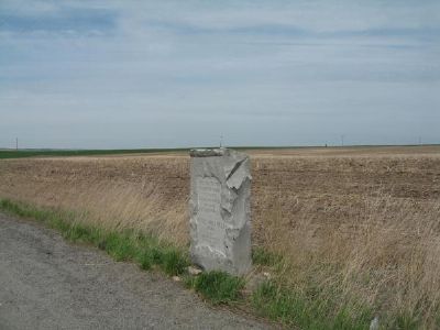
April 29, 2007
2. Colville - Walla Walla Road Marker
Credits. This page was last revised on June 16, 2016. It was originally submitted on November 27, 2007, by Kevin W. of Stafford, Virginia. This page has been viewed 2,881 times since then and 47 times this year. Photos: 1, 2. submitted on November 27, 2007, by Kevin W. of Stafford, Virginia.
