
City Centre in Windsor in Essex County, Ontario — Central Canada (North America)
The Detroit River
⎯⎯⎯
La rivière Détroit
⎯⎯⎯
Detroit Ziibi
Photographed by Dale K. Benington, August 9, 2010
1. The Detroit River Marker

The Detroit River
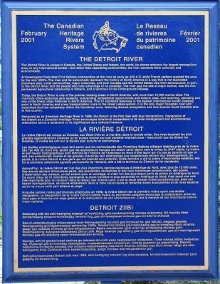
The Detroit River is unique in Canada, the United States and indeed, the world. Its shores embrace the largest metropolitan area on any international border - but rather than separating communities, the river connects them culturally and economically.
Archaeological finds date First Nations communities at the river as early as 400 A.D. while French settlers reached the area by the mid-1600's. The river and its watersheds represent the history of North America in a way that is not duplicated anywhere else. Local communities, major industries, and both Canada and the United States owe their development, in part, to the Detroit River and the people who took advantage of its potential. The river was the site of major battles, was the first permanent agricultural community in Ontario, and a terminus of the Underground Railway.
Today, the Detroit River is one of the premier boating areas in North America, with more than 12,000 marina slips. The riverfront offers extensive park systems, outstanding recreational opportunities and historic sites, bird watching, canoeing and one of the
this page online
Honoured as an American Heritage River in 1998, the Detroit is the first river with dual designations. Designation of the Detroit as a Canadian Heritage River encourages binational cooperation in its wise management and environmental restoration and is a testament to its significance as a national treasure.
La rivière Détroit
La rivière Détroit est unique au Canada, aux États-Unis et, à vrai dire, dans le monde entier. Ses rives touchent les plus grandes agglomérations urbaines qu'on puisse trouver sur une frontière internationale - mais plutôt que de diviser les localités, la rivière les unit sur le double plan culturel et économique.
Les fouilles archéologiques nous font savoir que les communautés des Premières Nations s'étaient établies

Photographed by Dale K. Benington, August 9, 2010
2. The Detroit River Marker
View looking south of historical marker in downtown riverside park.
Aujourd'hui, la rivière Détroit est l'un des plus importants centres nautiques d'Amérique du Nord, avec plus de 12 000 cales. Ses abords abritent d'immenses parcs, des possibilités récréatives et des lieux historiques sensationnels, des postes d'observation des oiseaux, un bel endroit pour le canotage, et c'est l'un des plus beaux ports de pêche en Amérique du Nord. Ce cours d'eau de 51 kilomètres représente le poste frontière le plus achalandé en Amérique du Nord; c'est aussi une voie très importante
Photographed by Dale K. Benington, August 9, 2010
3. The Detroit River Marker
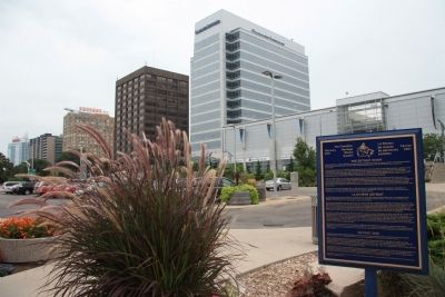
View looking southeast of historical marker with downtown Windsor business district in background.
Honorée comme rivière patrimoniale américaine en 1998, la rivière Détroit est la première rivière ayant une double désignation. La désignation de la rivière Détroit comme rivière du patrimoine canadien encourage la collaboration entre les deux pays et favorise une sage gestion et la restauration de son environnement. C'est la marque de son importance comme trésor national.
Detroit Ziibi
Odenaang ziibi eta ezhi-bezhgong maampii en'nookiiying, gchi-mookmaankiing miinwaa enkokamig. Mii maanda tibew ezhikenmaang emaamo-mchaamgag nenedwi'iing_gaa-zhi-taawgiwaad miinwaa gaa-zhi-shki'iw zhiwaad.
Gaa-bi-aaboodkamgejig mkaanaawaa ntam Nishnaabekiing maampii gaa-dnizwaad ko, goji 400 AD, megwaa gwonda Wemtigoozhiig gii-bidgoshnowaad aabtowiing 1600s. Giiwtaa'iing zlibiing gikendaanaawaa gaa-bi-zhiwebag North America gaago goji naasaab miinwaa gii-daa-mkigaadesnoo.
Photographed by Dale K. Benington, August 9, 2010
4. The Detroit River Marker
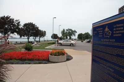
View looking east of historic marker, showing parking area adjacent to marker, and Detroit River just north of the historic marker and parking area.
Noongo, ezhi-bi-gwaabziwaad washme go mdaaswi-zhi-niizh waak naapkwaanan mibdenoon. Tibew miimaa niibna nwebwinan teg, zhaashgo gaa-bi-zhiwebag mkobiigaade, noowaabmaawaan bineshiiyan, jiimeng giyakwon ge giigoonkeng. Maanda naanmidna-zhi-bezhig ekoyaag ziibi emaamo-aabjichkaadeg maa North America miinwaa maa Gchi-miinan. Miigo eta ezhi-bezhigoong biinji Carolinian zone ewaawiinjigaadeg, gaago miinwaa daa-mkigaadesnoo goji.
Gchi-piitendaanaawaa Detroit ziibi maa 1998, ezhi-bezhgong nenedwi'iing dibendaagwog. Mnokiikmaawsiwin kidwinan pane gaagnig wii-bwaawnising.
Erected 2001 by The Canadian Heritage Rivers System.
Topics. This historical marker is listed in these topic lists: Environment • Industry & Commerce • Waterways & Vessels. A significant historical year for this entry is 400 CE.
Location. 42° 19.203′ N, 83° 2.47′ W. Marker is in Windsor, Ontario, in Essex County. It is in
Photographed by R. C., May 4, 2011
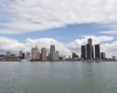
5. The Detroit River and the City of Detroit as Viewed from Windsor Canada
The Canadians feel that Detroit is a beautiful city when viewed from Canada.

Regionally, this marker is in the Southwest Ontario Area and in Southwestern Ontario. It is also in Central Canada. Globally, it is in North America, on the Great Lakes, in the Western Hemisphere, in the Western World, and in the Anglosphere. Historically, it finds itself in what was once a British colony, the Viceroyalty of New France, the Haudenosaunee (Iroquois) Confederacy, and Rupert’s Land.
Other nearby markers. At least 8 other markers are within walking distance of this marker: French Settlement on the South Shore (within shouting distance of this marker); The Rt. Hon. Herb Gray, PC., C.C., Q.C. (within shouting distance of this marker); The Great Western Railway (within shouting distance of this marker); The François Baby House / La Maison Baby (about 210 meters away, measured in a direct line); The Battle of Windsor - 1838 (about 210 meters away); Mary Ann Shadd Cary (1823-1893) (approx. 0.2 kilometers away); Original Home of Major F.A. Tilston V.C. Armoury (approx. 0.4 kilometers away); The Underground Railroad in Canada / Le Chemin de fer Clandestin au Canada (approx. 0.4 kilometers away). Touch for a list and map of all markers in Windsor.
Credits. This page was last revised on August 18, 2026. It was originally submitted on October 30, 2010, by Dale K. Benington of Toledo, Ohio. This page has been viewed 1,344 times since then and 29 times this year. Photos: 1, 2, 3, 4. submitted on October 30, 2010, by Dale K. Benington of Toledo, Ohio. 5. submitted on May 10, 2011, by Ronald Claiborne of College Station, Texas.
