Barney Circle in Southeast Washington in Washington, District of Columbia — The American Northeast (Mid-Atlantic)
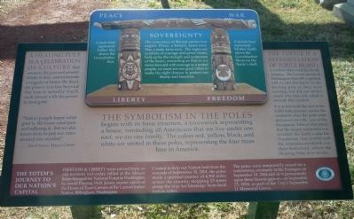
The Symbolism in the Poles
9-11 Memorial
— [Historic Congressional Cemetery] —
[Rendering of the Healing Totem Poles] Liberty - Freedom
Sovereignty
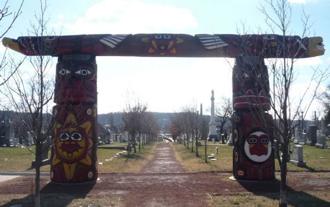
A male bear [carving on pole at left] represents Father Sky above the Grandfather Sun.
A female bear [carving on pole at right] represents Mother Earth above the Grandmother Moon on the Turtle’s shell.
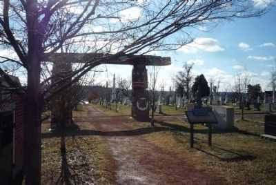
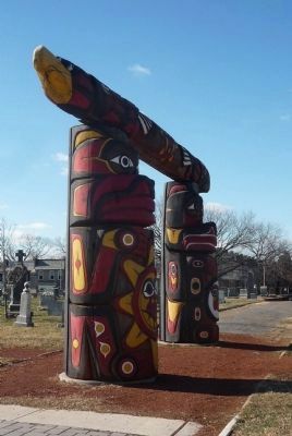
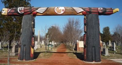
The Symbolism in the Poles begins with its basic structure, a framework representing a house, reminding all Americans that we live under one roof; we are one family. The colors red, yellow, black, and white are united in these poles, representing the four races here in America.
A Healing Pole is a celebration of culture that connects the past and present. While it may commemorate a tragedy or honor the dead its power reaches beyond the loss to actually touch each viewer with the power to heal grief.
“Native people know what grief is. We know what pain and suffering is. But we also know how to put our arms around one another” Jewell James, Master Carver.
The Turtle is a representation of Turtle Island, a symbol often used for North America.
The Lummi carvers of Washington State felt a spiritual call to add the turtle to the healing pole as they were carving, but did not understand why they felt called to include this symbol.
It was not until the end of the 4,500 mile journey across the continent when the poles were delivered into the care of the Piscataway Tribe of Maryland, that the deeper connection was revealed: the Turtle is also the Piscataway clan symbol and the Anacostia riverbank was their homeland, where the Healing Poles now reside.
Created to help our Nation heal from the wounds of September 11, 2001, the poles made a spiritual journey of 4,500 miles across the country, stopping 13 times along the way for blessings from local Indian tribes.
The poles were temporarily raised for a welcoming ceremony at the Pentagon on September 19, 2004 and then permanently
upon these historic grounds on September 23, 2004, as part of the City’s September 11 Memorial Grove.
Erected 2004 by TKF Foundation.
Topics. This historical marker is listed in these topic lists: 9/11 Attacks • Arts, Letters, Music • Cemeteries & Burial Sites • Native Americans • Peace. A significant historical date for this entry is September 11, 1864.
Location. This marker has been replaced by another marker nearby. It was located near 38° 52.825′ N, 76° 58.792′ W. Marker was in Southeast Washington in Washington, District of Columbia. It was in Barney Circle. Marker could be reached from the intersection of 17th Street Southeast and H Street Northeast, on the right when traveling north. The memorial is in the western section of the Historical Congressional Cemetery off the Prout Street walkway, south of the TKF Foundation Garden, and west of Congress Street. Touch for map. Marker was at or near this postal address: 715 17th Street Southeast, Washington DC 20003, United States of America. Touch for directions.
Other nearby markers. At least 8 other markers are within walking distance of this location. September 11 Healing Poles (here, next to this marker); September 11 Memorial Path (about 300 feet away, measured in a direct line); John Philip Sousa (about 300 feet away); Peter Perkins Pitchlynn (about 300 feet away);
Lee Dittman Shapiro 1949-1987 / James T. Lindelof 1957-1987 (about 300 feet away); Barney at Bladensburg (about 400 feet away); U.S. Arsenal Explosion Memorial (about 400 feet away); a different marker also named U.S. Arsenal Explosion Memorial (about 400 feet away). Touch for a list and map of all markers in Southeast Washington.
Related marker. Click here for another marker that is related to this marker. This marker has been replaced with the linked marker which has a different inscription.
Additional keywords. "Lummi 9/11 Healing Pole"; "Ward 6 September 11th Memorial"; American Indians; totem poles; Jewell James ("Indian" Name: tse-Sealth).
Credits. This page was last revised on January 30, 2023. It was originally submitted on January 29, 2011, by Richard E. Miller of Oxon Hill, Maryland. This page has been viewed 1,965 times since then and 92 times this year. Photos: 1, 2, 3, 4, 5. submitted on January 29, 2011, by Richard E. Miller of Oxon Hill, Maryland. • Bill Pfingsten was the editor who published this page.
