Manassas, Virginia — The American South (Mid-Atlantic)
Mayfield Civil War Fort
The Changing Fortunes of War
| — | The Manassas Museum System | — |
Photographed by Craig Swain, September 2, 2007
1. Mayfield Civil War Fort Marker
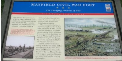
After the First Battle of Manassas on June 21, 1861, Confederate forces continued to hold Manassas Junction until March 1862. They evacuated Manassas and moved south in order to counter Union Gen. George B. McClellan’s plans to attack Richmond. During this period, Union forces occupied the abandoned Confederate earthworks.
Manassas Junction became an important supply base for the Federals. On August 26, 1862, Confederate Gen. Thomas J. “Stonewall” Jackson’s troops briefly recaptured the junction, which they looted and burned. When a small Union force advanced on the junction the next day and was repulsed, the Mayfield fort may have seen action.
Despite another Confederate victory at the Second Battle of Manassas (August 28-30, 1862), Union forces held Manassas Junction for the rest of the war. The earthworks built to oppose an army of invasion now served as a base for an army of occupation.
Erected by Virginia Civil War Trails.
Topics and series. This historical marker is listed in this topic list: War, US Civil. In addition, it is included in the Virginia Civil War Trails series list. A significant historical year for this entry is 1861.
Location. This marker has been replaced by another marker nearby.
this page online

Regionally, this marker was in the Washington Metropolitan Area and in Northern Virginia. It was also in the American South, specifically in the Upper South, and in the Mid-Atlantic. Globally, it was in North America, the Western Hemisphere, the Western World, and the Anglosphere. Historically, it found itself in what was once the territory of the Mississippian Culture, one of the original Thirteen Colonies, one of the Confederate States of America, and the Antebellum South.
Other nearby markers. At least 8 other markers are within walking distance of this location: The Hooes of Mayfield (a few steps from this marker); Preservation of Mayfield Fort (within shouting distance
Photographed by Craig Swain, September 2, 2007
2. Overlooking the Fort
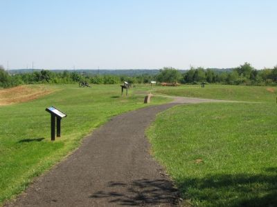
Marker is in the foreground, closest to the camera.
Other markers no longer nearby. Mayfield Civil War Fort (was within shouting distance of this marker but has been replaced with another marker now near it); a different marker also named Mayfield Civil War Fort (was within shouting distance of this marker but has been replaced with another marker now near it); a different marker also named Mayfield Civil War Fort (was within shouting distance of this marker but has been replaced with another marker now near it); a different marker also named Mayfield Civil War Fort (was within shouting distance of this marker but has been replaced with another marker now near it).
More about this marker. On the left is a photograph of the destruction left after Jackson’s occupation, “This photograph is believed to have been taken shortly after Stonewall Jackson's August 1862 raid on Manassas Juction and shows the destruction wrought by his troops. The Union soldiers are posing beside burned Orange & Alexandria Railroad rolling stock.”
On the right a painting carries the caption, “A soldiers artist’s rendering of the area of Manassas Junction. The artist was Private Robert K. Sneden, who, in nearly two years, produced hundreds of paintings while campaigning with the Union Army.”
Related markers. Click here for a list of markers that are related to this marker. To better understand the relationship, study each marker in the order shown.
Also see . . .
1. Mayfield Fort Historic Site - Manassas, Virginia. Explore Southern History website entry (Submitted on July 15, 2024, by Larry Gertner of New York, New York.)
2. Manassas Station Operations (August 25–27, 1862). Wikipedia entry (Submitted on July 15, 2024, by Larry Gertner of New York, New York.)
Credits. This page was last revised on July 15, 2024. It was originally submitted on September 8, 2007, by Craig Swain of Leesburg, Virginia. This page has been viewed 2,020 times since then and 38 times this year. Last updated on April 7, 2011, by Jonathan Carruthers of Bealeton, Virginia. Photos: 1, 2. submitted on September 8, 2007, by Craig Swain of Leesburg, Virginia.
