Near Fairfield in Freestone County, Texas — The American South (West South Central)
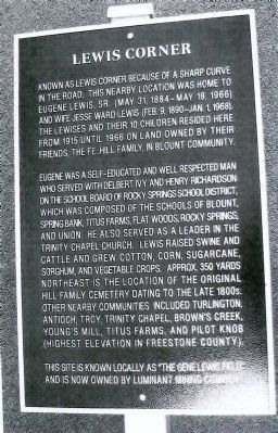
Lewis Corner
Photographed by Darlene White
1. Lewis Corner Marker
Eugene was a self-educated and well respected man who served with Delbert Ivy and Henry Richardson on the school board of Rocky Springs School District, which was composed of the schools of Blount, Spring Bank, Titus Farms, Flat Woods, Rocky Springs and Union. He also served as a leader in the Trinity Chapel Church. Lewis raised swine and cattle and grew cotton, corn, sugarcane, sorghum, and vegetable crops. Approx. 350 yards northeast is the location of the original Hill Family Cemetery dating to the late 1800s. Other nearby communites included Turlington, Antioch, Troy, Trinity Chapel, Brown's Creek, Young's Mill, Titus Farms, and Pilot Knob (highest elevaton in Freestone County).
This site is known locally as "The Gene Lewis Field" and is now owned by Luminant Mining Company.
Erected 2011 by Luminant Big Brown-Turlington.
Topics. This historical marker is listed in these topic lists: Agriculture • Animals • Cemeteries & Burial Sites. A significant historical year for this entry is 1915.
Location. 31° 46.699′ N, 96° 2.369′ W. Marker is near Fairfield, Texas, in Freestone County. It is on Blount Road (County Road 235), on the right when traveling north. Location is approximate. Touch for map. Marker is in this post office area: Fairfield TX 75840, United States of America. Touch for directions.

Regionally, this marker is in the Prairies & Lakes Region. It is also in the American South. Globally, it is in North America, a Gulf of Mexico state, the Western
this page online
Other nearby markers. At least 8 other markers are within 8 miles of this marker, measured as the crow flies: Antioch Cemetery (approx. 4.9 miles away); Ward Prairie Baptist Church (approx. 5.9 miles away); Lake Chapel Cemetery (approx. 6.1 miles away); Mt. Zion Methodist Church and Cemetery (approx. 6.2 miles away); Colonel Wm. L. Moody (approx. 7.3 miles away); W.L. Moody Confederate Reunion Grounds (approx. 7.3 miles away); Fairfield Female College (approx. 7½ miles away); Carter Log House (approx. 7.8 miles away). Touch for a list and map of all markers in Fairfield.
Credits. This page was last revised on June 16, 2016. It was originally submitted on June 29, 2011, by Darlene White of Ferris, Texas. This page has been viewed 1,066 times since then and 33 times this year. Photo 1. submitted on July 17, 2011, by Darlene White of Ferris, Texas. • J. J. Prats was the editor who published this page.
Editor’s want-list for this marker. Photo of installed marker and its surrounding area. • Confirmed coordinates of marker. • Can you help?
