Bonner - Loring near Bonner Springs in Wyandotte County, Kansas — The American Midwest (Upper Plains)
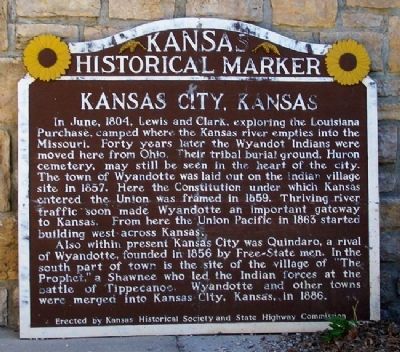
Kansas City, Kansas
In June, 1804, Lewis and Clark, exploring the Louisiana Purchase, camped where the Kansas river empties into the Missouri. Forty years later the Wyandot Indians were moved here from Ohio. Their tribal burial ground, Huron cemetery, may still be seen in the heart of the city. The town of Wyandotte was laid out on the Indian village site in 1857. Here the Constitution under which Kansas entered the Union was framed in 1859. Thriving river traffic soon made Wyandotte an important gateway to Kansas. From here the Union Pacific in 1863 started building west across Kansas.
Also within present Kansas City was Quindaro, a rival of Wyandotte, founded in 1856 by Free-State men. In the south part of town is the site of the village of "The Prophet," a Shawnee who led the Indian forces at the battle of Tippecanoe. Wyandotte and other towns were merged into Kansas City, Kansas, in 1886.
Erected by Kansas Historical Society and State Highway Commission.
Topics. This historical marker is listed in these topic lists: Exploration • Native Americans • Settlements & Settlers • Waterways & Vessels. A significant historical month for this entry is June 1804.
Location. 39° 6.437′ N, 94° 52.084′ W. Marker is near Bonner Springs, Kansas, in Wyandotte County. It is in Bonner - Loring. Marker is at the Wyandotte County Museum, in Wyandotte County Park. Touch for map. Marker is at or near this postal address: 631 North 126th Street, Bonner Springs KS 66012, United States of America. Touch for directions.
Other nearby markers. At least 8 other markers are within 3 miles of this marker, measured as the crow flies. Kansas Indian Reservations (here, next to this marker); The Ethnic Communities of Wyandotte County Sesquicentennial (a few steps from this marker); Bomber Builders (within shouting distance of this marker); The National Farmers Memorial (approx. 0.3 miles away); Julia Lee (approx. 2˝ miles away); The Golden Mean (approx. 2˝ miles away); Samuel Edward Ramey (approx. 2˝ miles away); "Jay" McShann (approx. 2˝ miles away). Touch for a list and map of all markers in Bonner Springs.
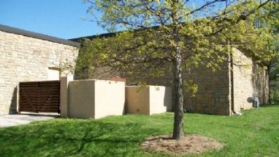
More about this marker. The marker has been moved from its original location and, as of April 2011, was in the outdoor storage area of the museum. Plans call for the marker to be erected on the museum grounds.
Also see . . .
1. Kansas City, Kansas. Wikipedia entry (Submitted on August 21, 2011, by William Fischer, Jr. of Scranton, Pennsylvania.)
2. About Kansas City, Kansas. Unified Government of Wyandotte County and Kansas City website entry (Submitted on August 21, 2011, by William Fischer, Jr. of Scranton, Pennsylvania.)
3. Morgan's History of Wyandotte County, Kansas (1911). Internet Archive website entry (Submitted on August 21, 2011, by William Fischer, Jr. of Scranton, Pennsylvania.)
4. Wyandotte County Museum
. Unified Government of Wyandotte County and Kansas City website entry (Submitted on August 21, 2011, by William Fischer, Jr. of Scranton, Pennsylvania.)
Credits. This page was last revised on February 10, 2023. It was originally submitted on August 21, 2011, by William Fischer, Jr. of Scranton, Pennsylvania. This page has been viewed 606 times since then and 14 times this year. Photos: 1, 2. submitted on August 21, 2011, by William Fischer, Jr. of Scranton, Pennsylvania.
Editor’s want-list for this marker. Photo and coordinates of marker once it has been erected on park grounds. • Can you help?

