Woburn in Middlesex County, Massachusetts — The American Northeast (New England)
Woburn
1630 - 1930
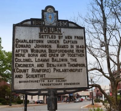
Photographed by Russell C. Bixby, May 9, 2011
1. Woburn Marker
Erected 1930 by Massachusetts Bay Colony-Tercentenary Commission.
Topics and series. This historical marker is listed in these topic lists: Colonial Era • War, French and Indian. In addition, it is included in the Massachusetts Bay Colony—Tercentenary Commission Markers series list. A significant historical year for this entry is 1642.
Location. 42° 28.788′ N, 71° 9.14′ W. Marker is in Woburn, Massachusetts, in Middlesex County. It is on Pleasant Street near Winn Street. Located on Woburn Town Common across from Town Hall. Touch for map. Marker is in this post office area: Woburn MA 01801, United States of America. Touch for directions.

Regionally, this marker is in Greater Boston. It is also in the American Northeast, in New England, and on the Eastern Seaboard. Globally, it is in the North Atlantic Region, North America, the Western Hemisphere, the Western
this page online
Other nearby markers. At least 8 other markers are within 3 miles of this marker, measured as the crow flies: Woburn Public Library (about 500 feet away, measured in a direct line); Woburn Revolutionary War Memorial (approx. 0.3 miles away); Old Middlesex Canal (approx. 0.7 miles away); John Harvard's Land (approx. 1.6 miles away); Battle Road (approx. 2 miles away); Converse Bridge (approx. 2.1 miles away); Site of First House (approx. 2.1 miles away); The Symmes Farm (approx. 2.7 miles away). Touch for a list and map of all markers in Woburn.
Also see . . . Historical Markers Erected by Massachusetts Bay Colony. (Submitted on May 9, 2011, by Russell Chaffee Bixby of Bernardston, Massachusetts.)
Credits. This page was last revised on June 16, 2016. It was originally submitted on May 9, 2011, by Russell Chaffee Bixby of Bernardston, Massachusetts. This page has been viewed 1,099 times since then and 62 times this year. Last updated on October 26, 2011, by Michael Tiernan of Danvers, Massachusetts. Photo 1. submitted on May 9, 2011, by Russell Chaffee Bixby of Bernardston, Massachusetts. • Bill Pfingsten was the editor who published this page.
