Westborough in Worcester County, Massachusetts — The American Northeast (New England)
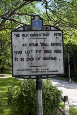
The Old Connecticut Path
1630 - 1930
An Indian trail before 1630 left the road here to go over Fay Mountain.
Erected 1930 by Massachusetts Bay Colony-Tercentenary Commission.
Topics and series. This historical marker is listed in these topic lists: Colonial Era • Native Americans. In addition, it is included in the Massachusetts Bay Colony—Tercentenary Commission Markers series list. A significant historical year for this entry is 1630.
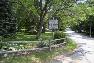
Location. 42° 14.932′ N, 71° 37.111′ W. Marker is in Westborough, Massachusetts, in Worcester County. Marker is on Ruggles Street. Marker is located at the intersection of Ruggles Street, Mt. Pleasant Street and Valley Brook Road. Touch for map. Marker is in this post office area: Westborough MA 01581, United States of America. Touch for directions.
Other nearby markers. At least 8 other markers are within 6 miles of this marker, measured as the crow flies. Hassanamesit (approx. 4˝ miles away); Gen. Henry Knox Trail (approx. 5 miles away); The Minuteman (approx. 5 miles away); "Flame of the Marathon Run" (approx. 5.1 miles away); Thomas Hooker Trail (approx. 5.1 miles away); Indian Reservation (approx. 5.1 miles away); Northborough World War I Memorial (approx. 5.2 miles away); First Meetinghouse in Hopkinton (approx. 5.3 miles away).
Also see . . .
1. Historical Markers Erected by Massachusetts Bay Colony Tercentenary Commission (1930) .
Original 1930 publication by the Commonwealth of Massachusetts of Tercentenary Commission Markers, commemorating the three hundredth anniversary of the Massachusetts Bay Colony. (Submitted on June 8, 2011, by Russell Chaffee Bixby of Bernardston, Massachusetts.)
2. Old Connecticut Path. Wikipedia link to background material on The Old Connecticut Trail. (Submitted on June 14, 2011, by Russell Chaffee Bixby of Bernardston, Massachusetts.)
3. Sudbury Valley Trustees. A description published by the Sudbury Valley Trustees provides a capsule of this early colonial expansion route from Massachusetts Bay Colony into Connecticut: “Storied cross-country foot trails include Vermont’s Long Trail, and the Appalachian Trail, which follows the ridges from Maine to Georgia. Local walkers might know of the much younger Bay Circuit Trail, which arcs 150 miles around the Hub. But the first long-distance American footpath to bear an English name predates these by centuries. Its route, chosen by Native Americans, remains in use in several of our towns. And it makes this claim to historical significance: upon it the English began their westward journey across North America. We call it Old Connecticut Path. In the earliest years of its settlement, the Massachusetts Bay Colony ran short of grain. Nipmuck farmers in the fertile valley of the Connecticut River, who had reaped an abundant harvest, loaded some of their surplus into birch bark backpacks. Confident of a seller’s market for corn at the new English colony, they walked a familiar route to the settlements at the mouth of the Charles River, where they traded food for goods made of metal and cloth. English fur traders followed the same trail to gather pelts from native trappers, with the result that when settlers started leaving the Bay Colony for Connecticut they were well aware of the path that skirted hills and swamps and crossed streams at time-tested fords. In 1636, in a Puritan exodus, Thomas Hooker led a hundred of his followers on this route from Boston to Connecticut, where they founded Hartford. They are said to have camped near Whitehall Pond in Hopkinton. It was a two weeks’ hike. Their 160 cattle—the travelers drank milk along the way—probably made the trail more distinct for those who came after. Old Connecticut Path led west from newly-settled Watertown and bent to the south where it entered the east side of the new town of Sudbury, now Wayland. The Native American trail took an expedient route, following the lower contour of Wayland’s Reeve’s Hill, which kept it well above the soggy river meadows and led to the best place to wade Cochituate Brook. The trail crossed what is now Framingham, then headed west toward Hopkinton, threading between the Charles and Sudbury Rivers. A synonym for ‘path’ was ‘way’; the best trails kept to higher, drier ground and were thus ‘high ways.’ By 1643 Sudbury called it the Old Connecticut Path, and in 1672 it became the first colonial postal road. I like to picture a Watertown child of the 1630’s, gazing at the point where the path left the settlement and disappeared westward into the woods, toward the continent’s unexplored interior. As he looked at that single-file track, what did he imagine about his journey and his life? A foot trail leading someplace far away can evoke dreams of distance and destination, and, in the restless, can arouse a compelling wanderlust.” (Submitted on June 14, 2011, by Russell Chaffee Bixby of Bernardston, Massachusetts.)
4. The Bay Path and Along the Way (Chapter 15). USGenNet, a non-profit, free-access provider of online websites for educational purposes; supports a page based on the work of Levi Badger Chase in the book The Bay Path and Along the Way. Chapter 15 of this text describes The Bay Path crossing the towns of Grafton, Westborough and on to Hopkinton. (Submitted on June 20, 2011, by Russell Chaffee Bixby of Bernardston, Massachusetts.)
Credits. This page was last revised on May 7, 2021. It was originally submitted on June 8, 2011, by Russell Chaffee Bixby of Bernardston, Massachusetts. This page has been viewed 1,565 times since then and 57 times this year. Last updated on October 26, 2011, by Russell Chaffee Bixby of Bernardston, Massachusetts. Photos: 1, 2. submitted on June 8, 2011, by Russell Chaffee Bixby of Bernardston, Massachusetts. • Bill Pfingsten was the editor who published this page.

