Medfield in Norfolk County, Massachusetts — The American Northeast (New England)
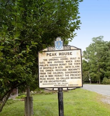
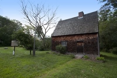
Peak House
1630 - 1930
Photographed by Russell C. Bixby, August 31, 2011
1. Peak House Marker
Erected 1930 by Massachusetts Bay Colony-Tercentenary Commission.
Topics and series. This historical marker is listed in these topic lists: Colonial Era • Indigenous Peoples and Communities. In addition, it is included in the King Philip's War 1675-1676, and the Massachusetts Bay Colony—Tercentenary Commission Markers series lists. A significant historical year for this entry is 1651.
Location. 42° 11.395′ N, 71° 17.804′ W. Marker is in Medfield, Massachusetts, in Norfolk County. It is at the intersection of Main Street (Massachusetts Route 109) and Pound Street, on the right when traveling west on Main Street. Touch for map. Marker is in this post office area: Medfield MA 02052, United States of America. Touch for directions.

Regionally, this marker is in Greater Boston. It is also in the American Northeast, in New England, and on the Eastern
this page online
Other nearby markers. At least 8 other markers are within 4 miles of this marker, measured as the crow flies: First Baptist Church (approx. 0.4 miles away); John Parcell Ross Jr. (approx. 0.4 miles away); Straw Hat Factory (approx. 0.4 miles away); Medfield Town Hall (approx. half a mile away); Site of the Homestead of Rev. John Wilson, (approx. half a mile away); Clarence Meredith Cutler (approx. half a mile away); Future Performing Arts Center (approx. 2.4 miles away); The Paper and Cotton Mill of Bradford Lewis (approx. 3.6 miles away). Touch for a list and map of all markers in Medfield.
Also see . . .
1. Historical Markers Erected by Massachusetts Bay Colony Tercentenary Commission (1930). Original 1930 publication by the Commonwealth of Massachusetts of Tercentenary Commission Markers, commemorating the three hundredth anniversary of the Massachusetts Bay Colony. (Submitted on August 31, 2011, by Russell Chaffee Bixby of Bernardston, Massachusetts.)
2. The Correspondence of John Cotton Jr. - Mass. Colonial Society.
Photographed by Russell C. Bixby, August 31, 2011
2. Peak House- Medfield, Massachusetts
Those Native bands fighting the English were growing desperate: short of food, unable to encamp for very long, and with women and children to care for. Nevertheless, they were still quite capable of taking the offensive. In the early morning hours of 21 February 1676, a Native force estimated at 300 to 400 warriors infiltrated “every part of the town” of Medfield, Massachusetts, set fire to houses and outbuildings, and then shot inhabitants and soldiers as they responded to the alarm.(Submitted on April 22, 2026, by G.W.Bartlett of Hingham, Massachusetts.)
3. History of Medfield: King Philip's War and the Burning of Medfield.
It appears most likely that a guard was kept through the night; and, as daylight appeared, supposing danger passed, it was taken off. But, during the darkness of the night, the Indians had crept stealthily among trees and bushes growing upon the unimproved land adjoining the homesteads, and, secreting themselves, were in readiness to attack every part of the town at a given signal.(Submitted on April 22, 2026, by G.W.Bartlett of Hingham, Massachusetts.)
Credits. This page was last revised on May 22, 2026. It was originally submitted on August 31, 2011, by Russell Chaffee Bixby of Bernardston, Massachusetts. This page has been viewed 1,133 times since then and 55 times this year. Last updated on October 26, 2011, by Russell Chaffee Bixby of Bernardston, Massachusetts. Photos: 1, 2. submitted on August 31, 2011, by Russell Chaffee Bixby of Bernardston, Massachusetts. • Bill Pfingsten was the editor who published this page.
