Ashland in Saunders County, Nebraska — The American Midwest (Upper Plains)
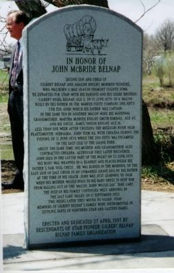
In Honor Of John McBride Belnap
April 27, 1997
1. In Honor Of John McBride Belnap Marker
Less than one week after crossing the Missouri River near Plattsmouth, Nebraska. John took ill with cholera during the evening of 21 June 1850 while the 2nd Fifty was encamped on the east side of the Saline Ford.
About the same time his mother and grandmother also contracted cholera, although they later recovered John died in the latter part of the night on 22 June 1850. His body was wrapped in a blanket and placed inside his father's oak tool chest. He was buried in the morning on the east side of Salt Creek in an unmarked grave dug by his father at the time of his death. John was just learning to talk when his mother would hold to his baby dress to keep him from falling out of the wagon. John would say "take care."
The rest of his family continued west arriving in the Salt Lake Valley on 17 September 1850. Two weeks later they moved to Ogden, Utah.
Members of Gilbert Belnap's family were instrumental in settling parts of Northern Utah and Eastern Idaho.
Erected and dedicated 27 April 1997 by descendants of Utah Pioneer Gilbert Belnap. Belnap Family Organization
[BACK SIDE]
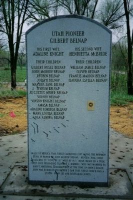
Utah Pioneer Gilbert Belnap
[Lists wives Adaline Knight and Henrietta McBride and their children]
Erected 1997 by Belnap Family Organization.
Topics. This historical marker is listed in these topic lists: Cemeteries & Burial Sites
this page online
Location. 41° 2.347′ N, 96° 21.803′ W. Marker is in Ashland, Nebraska, in Saunders County. It is at the intersection of Silver Street and North 10th Street, on the right when traveling west on Silver Street. Touch for map. Marker is in this post office area: Ashland NE 68003, United States of America. Touch for directions.

Regionally, this marker is in Eastern Nebraska and in Greater Lincoln. It is also in the American Midwest, in the Corn Belt, and on the prairies. Globally, it is in North America, the Western Hemisphere, the Western World, and the Anglosphere. Historically, it finds itself in what was once the Louisiana Purchase.
Other nearby markers. At least 8 other markers are within 7 miles of this marker, measured as the crow flies: The Mormon Pioneer Trail (about 800 feet away, measured in a direct line); The Ox-Bow Trail (approx. 0.3 miles away); Prehistoric Burial Site (approx. 2.6 miles away); Platte River (approx. 3½ miles away); Native Americans in the Lower Platte Valley (approx. 5½ miles away); Melia
April 27, 1997
2. In Honor Of John McBride Belnap Marker (back side)
Additional keywords. Mormon Pioneer Trail Sesquicentennial
Credits. This page was last revised on December 22, 2024. It was originally submitted on November 2, 2011, by Brent J. Belnap of New York, New York. This page has been viewed 1,832 times since then and 37 times this year. Photos: 1, 2. submitted on November 2, 2011, by Brent J. Belnap of New York, New York. • Bill Pfingsten was the editor who published this page.
