Hastings in Dakota County, Minnesota — The American Midwest (Upper Plains)
Native Cultures
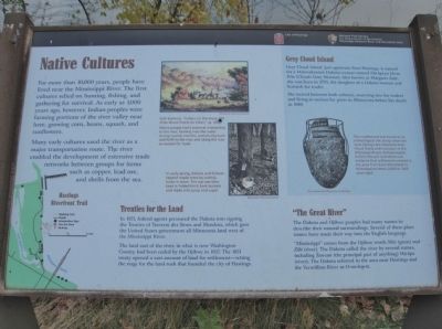
For more than 10,000 years, people have lived near the Mississippi River. The first cultures relied on hunting, fishing, and gathering for survival. As early as 1,000 years ago, however, Indian peoples were farming portions of the river valley near here, growing corn, beans, squash, and sunflowers.
Many early cultures used the river as a major transportation route. The river enabled the development of extensive trade networks between groups for items such as copper, lead ore, and shells from the sea.
Treaties for the Land
In 1851, federal agents pressured the Dakota into signing the Treaties of Traverse des Sioux and Mendota, which gave the United States government all Minnesota land west of the Mississippi River.
The land east of the river, in what is now Washington County, had been ceded by the Ojibwe in 1837. The 1851 treaty opened a vast amount of land for settlement — setting the stage for the land rush that founded the city of Hastings.
"The Great River"
The Dakota and Ojibwe peoples had many names to describe their natural surroundings. Several of these place names have made their way into the English language.
"Mississippi" comes from the Ojibwe words Misi (great) and Zibi (river). The Dakota called the river by several names, including Tan-can (the principal part of anything) Wa-kpa (river). The Dakota referred to the area near Hastings and the Vermillion River as O-wo-bop-te.
Grey Cloud Island
Grey Cloud Island, just upstream from Hastings, is named for a Mdewakanton Dakota woman named Ma-hpi-ya Ho-ta-Win (Clouds Grey Woman). Also known as Margaret Aird, she was born in 1793, the daughter of a Dakota woman and Scottish fur trader.
She moved between both cultures, marrying two fur traders and living at various fur posts in Minnesota before her death in 1849.
Erected by City of Hastings; National Park Service, U.S. Department of the Interior, Mississippi National River and Recreation Area.
Topics and series. This historical marker is listed in these topic lists: Native Americans • Settlements & Settlers • Waterways & Vessels. In addition, it is included in the Minnesota Historical Society series list. A significant historical year for this entry is 1851.
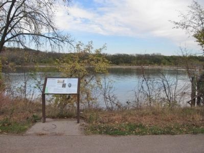
Location. 44° 45.164′ N, 92° 51.781′ W. Marker is in Hastings, Minnesota, in Dakota County. Marker can be reached from Lock and Dam Road, 0.7 miles north of 2nd Street West, on the right when traveling north. Marker is along the Hastings Riverfront Trail in the Flint Hills Resources - Riverfront Nature Preserve. Touch for map. Marker is in this post office area: Hastings MN 55033, United States of America. Touch for directions.
Other nearby markers. At least 8 other markers are within walking distance of this marker. Enjoying the River (approx. 0.2 miles away); Living in the Water (approx. 0.4 miles away); Shaping the River (approx. 0.4 miles away); Going with the Flow (approx. 0.6 miles away); River Habitats (approx. 0.6 miles away); Downtown Develops (approx. ¾ mile away); American Legion Veterans Memorial (approx. ¾ mile away); Spiral Bridge (approx. ¾ mile away). Touch for a list and map of all markers in Hastings.
More about this marker. [photo captions, left to right]
• Seth Eastman, "Indians on the move, 140 miles above Prairie du Chein," ca. 1845.
Native people had a seasonal relationship to the river, farming near the water during warmer months, and moving back and forth to the river and along the river as needed for trade. Minnesota Historical Society
• In early spring, Dakota and Ojibwe tapped maple trees by cutting holes in them. The sap was then kept in folded birch bark buckets and made into syrup and sugar. Minnesota Historical Society
• This crushed pot was found at an archeological site along what was once Spring Lake (opposite Grey Cloud Island and now part of the Mississippi River).
Archaeologists believe this pot and others are evidence that settlements existed in the area from Early Woodland to Mississippian times (2,600 to 1,100 years ago). The Institute for Minnesota Archeology
Also see . . .
1. Heritage travel: Dakota and Ojibwe. Heritage Travel website entry:
Despite centuries of disruption, their cultures survive. (Submitted on November 24, 2011.)
2. Treaty of Traverse des Sioux. Wikipedia entry. (Submitted on November 24, 2011.)
3. Treaty of Mendota. Wikipedia entry. (Submitted on November 24, 2011.)
4. Historical notes of Grey Cloud Island and its vicinity. Internet Archive website entry (Submitted on November 24, 2011.)
Credits. This page was last revised on February 27, 2022. It was originally submitted on November 24, 2011, by Keith L of Wisconsin Rapids, Wisconsin. This page has been viewed 1,022 times since then and 26 times this year. Photos: 1, 2, 3. submitted on November 24, 2011, by Keith L of Wisconsin Rapids, Wisconsin.


