San Juan Capistrano in Orange County, California — The American West (Pacific Coastal)
Historic Town Center Park / The Mendelson Inn
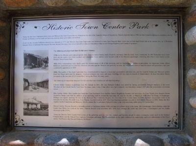
Historic Town Center Park
Today the San Juan Capistrano down town and Mission San Juan Capistrano are situated on the site of the Juaneño village of Acjachema. History explains that in 1769 the first Spanish exploratory expedition, led by Gaspar de Portola, traveled north in California passing about seven miles east of here.
A site for the seventh California mission was selected in 1775 and Mission San Juan Capistrano was believed to have been founded three miles east on San Juan Creek (not at its current site). In 1776 Father Junipero Serra re-dedicated the original Mission site and two years later it was moved to its present location at what is now Ortega Highway and Camino Capistrano.
The following are important dates in this area's history:
1794: As the Mission grew and prospered, forty Juaneno Indian houses made of adobe, and many with tile roofs, were constructed. In 1807 thirty-four more were built and the earlier ones were repaired and remodeled. Some adobes were located south of the Mission quadrangle, extending into what is now known as the Historic Town Center Park.
1821: With independence from Spain came the secularization of all of the missions, and the beginnings of Indian emancipation. An American visitor, Alfred Robinson, author of Life in California observed that although the Mission was partially in ruins, the 5-6 parallel rows of Janeno homes still presented a neat and comfortable appearance in 1829.
1841: The pueblo of San Juan Capistrano was commissioned to organize a municipal government and town lots, and the Juaneno Indians and Mexican settlers from San Diego petitioned for property. Local government was weak and many buildings fell into ruin as a result of abandonment. At least four adobe homes remained on the east side of El Camino Real, facing the Plaza, for many years.
The following are important structures for this area that once stood or are still standing today:
Canedo Adobe: Granted to petitioner Jose M. Cañedo in 1841. His son, Salvador Cañedo was noted for having accidentally brought smallpox to the town. Members of the Cañedo family lived there for many years. Later, it had other uses, but eventually was torn down around 1965 after the preservation movement failed.
Blas Aguilar Adobe: Blas Aguilar purchased the Casa Esperanza from Juaneno Indian Magdalena Amador and next door, the Casa Tejada from Janeno Indian Zepherino Teroje (and with the addition of an enclosing wall he created his hacienda). He was the Alcalde, or Mayor, in 1848 when the Treaty of Guadalupe-Hildalgo was signed, marking the end of the Mexican War. California became the 31st state of the United States in 1850. Aguilar's descendants lived in the hacienda for decades. Its south wing, Casa Tejada, was destroyed in 1937. The Casa Esperanza portion was sold to the Catholic Diocese in 1940. Today, the Blas Aguilar Adobe Foundation and Museum, which contains the Acjachemen Cultural Center, is the only remaining adobe along El Camino Real.
Burruel Adobe: Thomas Burruel, a Sonoran, moved to Capistrano before 1850, and had his cobblers shop in his home. His housekeeper, Chola Martina, aided the bandit Juan Flores in a raid on the town. Thomas Burruel died sometime after 1876, and although the adobe had other uses, it deteriorated and was finally destroyed in the 1970's.
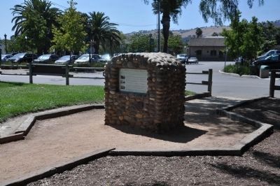
Today the Historic Town Center park serves as a gathering spot for residents, visitors and business people to enjoy community events such as the Summer Concert Series and the Annual Tree Lighting Ceremony and more. The establishment on the park celebrates the community, and is an embodiment of the City's motto, "To Preserve the Past and Enhance the Future."
The Mendelson Inn
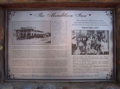
On April 19, 1875, Mark Mendelson purchased this land with a wood-frame building for $100 in gold from Manuel and Paula Garcia. Recognizing that San Juan Capistrano was the central point between Santa Ana and San Diego for travelers going by stage coach, he established the Mendelson Inn, later known as the Mendelson Mission Inn. Many would stay overnight to rest or visit the old Mission ruins. Some traveled on to the San Juan Hot Springs, on what is now the Ortega Highway. Rooms at the Inn rented for $1.50 to $3.00 a night.
The Mendelson Inn became a popular hotel and social point for members of California Society. It was the scene of many banquets and balls. For those who came to visit the Forster families or Judge Richard Egan, it was THE place to stay.
Well-known Polish actress, Madame helena Modjeska, would often arrive in her horse and carriage frmo her home in what is now Modjeska Canyon and leave it at the Inn when travelling by train to Los Angeles. The great Mission restorer, Father St. John O'Sullivan, stayed many weeks, under the care of the Mendelsons, while he was recovering from his recurring bouts of tuberculosis. The silent movie producer, D.W. Griffith, actors Mary Pickford and Max Sennet and company stayed there in 1910 when they made the first movie film to be produced in San Juan Capistrano. They were followed by many other movie companies and actors as they enjoyed the good weather and old west scenery.
On the back of the lot were two utility buildings. One houses carbide used to make gas for the interior lights. The other, an old adobe built by the Juaneno Indians, was used for storing fuel oil. Inside the hotel was the haberdashery and a general store that sold clothing. Ed Mendelson, son of Mark Mendelson, was a butcher who cut the meat daily for the hotel guests and customers. There was no refrigeration. Pigs, chickens and other fowl were raised on the property. When one of the periodic floods wiped out bridges on both ends of town, the hotel was a great resource for feeding the stranded villagers.
Three generations of Mendelsons lived in the Mendelson Inn and most of the grand-children were born in the Inn. The last of these generations is Richard Mendelson, son of Ed. He became the Town patriarch in 1995 in recognition of his pioneer family and their many contributions to the community. He was born at the Inn in 1910. His grandmother, Clara, sold the hotel and property to the Archdiocese of Los Angeles in 1931 for $5000. The hotel was torn down in 1932.
Topics and series. This historical marker is listed in these topic lists: Hispanic Americans • Native Americans • Notable Places • Settlements & Settlers. In addition, it is included in the Portolá Expedition series list. A significant historical month for this entry is April 1778.
Location. 33° 30.039′ N, 117° 39.698′ W. Marker is in San Juan Capistrano, California, in Orange County. Marker is on El Camino Real, on the right when traveling north. Touch for map. Marker is at or near this postal address: 31862 El Camino Real, San Juan Capistrano CA 92675, United States of America. Touch for directions.
Other nearby markers. At least 8 other markers are within walking distance of this marker. Blas Aguilar Adobe (within shouting distance of this marker); Esslinger Building (about 300 feet away, measured in a direct line); Manuel Garcia Adobe (about 300 feet away); Avila Adobe (about 300 feet away); Garcia Adobe (about 300 feet away); Provincial Building (about 400 feet away); Domingo Yorba Adobe (about 400 feet away); Site of the Valenzuela Adobe (about 400 feet away). Touch for a list and map of all markers in San Juan Capistrano.
Credits. This page was last revised on April 7, 2022. It was originally submitted on January 24, 2012, by Michael Kindig of Elk Grove, California. This page has been viewed 1,396 times since then and 57 times this year. Photos: 1, 2, 3. submitted on January 24, 2012, by Michael Kindig of Elk Grove, California. • Syd Whittle was the editor who published this page.


