Near Ketchum in Mayes County, Oklahoma — The American South (West South Central)
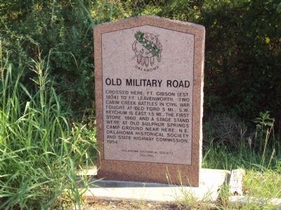
Old Military Road
Erected 1995 by Oklahoma Historical Society and State Highway Commission. (Marker Number 151-1995.)
Topics and series. This historical marker is listed in these topic lists: Native Americans • Roads & Vehicles • War, US Civil. In addition, it is included in the Oklahoma Historical Society series list. A significant historical year for this entry is 1860.
Location. 36° 31.479′ N, 95° 3.45′ W. Marker is near Ketchum, Oklahoma, in Mayes County. Marker is on West Ketchum Road (Oklahoma Route 85) 0.1 miles east of Oklahoma Route 82, on the right when traveling east. Touch for map. Marker is in this post office area: Ketchum OK 74349, United States of America. Touch for directions.
Other nearby markers. At least 8 other markers are within 8 miles of this marker, measured as the crow flies. 1st Kansas Colored Volunteer Infantry (approx. 4.3 miles away); 3rd Indian Homeguards (approx. 4.3 miles away); Confederate Soldiers (approx. 4.3 miles away); 2nd Indian Homeguards (approx. 4.3 miles away); 14th Kansas Cavalry (approx. 4.4 miles away); 6th Kansas Cavalry (approx. 4.4 miles away); Cabin Creek (approx. 4.4 miles away); Grand River Dam (approx. 7.3 miles away).
More about this marker. Marker is near the tree-line on a south side pull-off of OK-85 immediately East of the OK-82 junction. There is a blue "Historic Marker" sign pointing to its location.
Credits. This page was last revised on March 16, 2024. It was originally submitted on February 12, 2012, by Michael Manning of Woodlawn, Tennessee. This page has been viewed 1,162 times since then and 68 times this year. Photo 1. submitted on February 12, 2012, by Michael Manning of Woodlawn, Tennessee. • Bill Pfingsten was the editor who published this page.
Editor’s want-list for this marker. A photo of the marker and the surrounding area in context. • Can you help?
