Petersburg, Virginia — The American South (Mid-Atlantic)
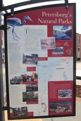
Petersburg’s Natural Parks
Typical of the uniquely American “wilderness” tradition of the late nineteenth and early twentieth centuries, Lee Park was developed with an emphasis on natural scenery and native flora as a symbol of local pride and a refuge from the ills of urban life. The centerpiece of the 331-acre park is Willcox Lake, originally created to supply water to the city. Lee Park is the site of a groundbreaking, depression-era WPA program where African American and white women worked together to create a wildflower and bird sanctuary within the park’s boundaries. Today, trails lead from the main road and picnic pavilion around the lake and through the park where the native plant and bird sanctuaries are carefully being restored through the efforts of the Willcox Watershed Conservancy.
Appomattox River Heritage Trail
The Appomattox River is a major tributary of the James River flowing east through central Virginia’s Piedmont and Coastal plain. It is an important regional resource that is unique and irreplaceable. The Appomattox River Heritage Trail is a dynamic, growing trail system. It was created through the support of public and private partners working together to preserve, protect and interpret the river as the cultural and natural resource that is the heart of our regional identity. The trail offers a unique opportunity to experience the beauty and power of the Appomattox River. The Pocahontas portion of the trail runs next to the Diversion Channel, built in 1909 to allow the flood waters from the river to flow around Petersburg’s harbor. Follow the Pocahontas Path along the water’s edge to find a series of interpretive waysides and seating areas. Other individual segments of the trail are accessible as you head further west past the falls and along the canal to the abutment dam. At several locations the trail connects to Petersburg’s historic downtown neighborhoods. Stop by the Visitor Center for more detailed information to guide your further explorations of the river.
Appomattox Riverside Park
Following an intact, 3-mile section of the early 19th century Upper Appomattox Canal, Appomattox Riverside Park—historically known as Ferndale Park—offers hiking along the original canal towpath as well as kayak access to the river and the canal. Long flat-bottom boats known as Batteaus were once used on the canal to bring goods to market in Petersburg from as far west as Farmville. The hiking trail starts at historic Ferndale Park, the location of a Victorian park that once boasted a carousel and movie house. As you walk along the trail, keep an eye out for the otters that live along the banks of the canal. Fly fishing is a favorite of smallmouth bass anglers along this stretch of the river’s rapids.
Battersea
This 37-acre riverfront estate contains the nationally significant Palladian villa built by John Banister III in 1767 and hosts walking trails and wildlife areas along the upper falls of the Appomattox River. Walking along the river trail you can see glimpses of Petersburg’s early industrial history as you pass the ruins of mills, dams, quarries and spillways that, for three centuries, have utilized the river’s falls for power. Hike to Indian Town Creek, the site of one of the largest Native American trading sites along the early frontier. Just upstream from its confluence with the Appomattox you will find the remains of the large stone aqueduct that once carried the water of the Upper Appomattox Canal over the ravine and across the southern edge of Battersea.
Erected by City of Petersburg.
Topics and series. This historical marker is listed in these topic lists: Charity & Public Work • Environment • Horticulture & Forestry • Man-Made Features. In addition, it is included in the Works Progress Administration (WPA) projects series list. A significant historical year for this entry is 1909.
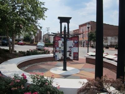
Location. 37° 13.99′ N, 77° 24.264′ W. Marker is in Petersburg , Virginia. Marker is at the intersection of East Old Street and Rock Street, on the right when traveling east on East Old Street. Touch for map. Marker is at or near this postal address: 9 E Old St, Petersburg VA 23803, United States of America. Touch for directions.
Other nearby markers. At least 8 other markers are within walking distance of this marker. Petersburg National Battlefield (here, next to this marker); Old Market Square (here, next to this marker); Architectural Heritage (here, next to this marker); Petersburg’s Old Towne (here, next to this marker); Pamplin Historical Park (here, next to this marker); Touring Old Towne (here, next to this marker); Arts & Recreation (here, next to this marker); Petersburg Museums (here, next to this marker). Touch for a list and map of all markers in Petersburg.
More about this marker. The marker contains several photographs with the captions:
The 18 acre Willcox Lake is a prominent feature in Lee Park.
1936 photo of women in the WPA program planting wildflowers on the steep slopes of Lee Park.
The WPA pavilion at the entry way is undergoing rehabilitation and can be used for gatherings.
Six Eagle Scouts completed their service projects with the construction of trailheads and waysides along the Appomattox River Heritage Trail.
Below: view of the Appomattox looking from Campbell’s Bridge eastward, showing the now unused railroad bridge abutments. One of the last remaining mill buildings along the river can be seen on the left.
Left: a view of the footpath above Campbell’s Bridge showing the trail bridge across one of the River’s many spillways—remnants of its industrial past.
Take a walk along the Upper Appomattox Canal along the towpath used for two centuries to bring goods from the hinterlands down into Petersburg to sell.
Early twentieth century postcard, showing Ferndale Park (now Appomattox Riverside Park).
View of the spillway arches that at one time allowed water to flow under the Pocahontas Mills building.
Aerial view of Battersea Mansion and grounds.
Credits. This page was last revised on February 2, 2023. It was originally submitted on July 9, 2012, by Bernard Fisher of Richmond, Virginia. This page has been viewed 548 times since then and 17 times this year. Photos: 1, 2. submitted on July 9, 2012, by Bernard Fisher of Richmond, Virginia.

