El Dorado Springs in Cedar County, Missouri — The American Midwest (Upper Plains)
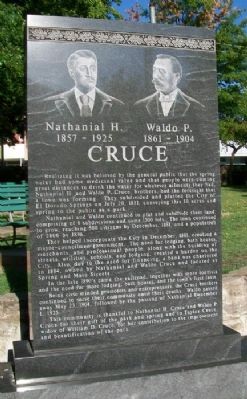
Nathaniel H. and Waldo P. Cruce
1857 - 1925 and 1861 - 1904
Realizing it was believed by the general public that the spring water had some medicinal value and that people were coming great distances to drink the water for whatever ailments they had, Nathaniel H. and Waldo P. Cruce, brothers, had the foresight that a town was forming. They subdivided and platted the City of El Dorado Springs on July 20, 1881, conveying this 10 acres and spring to the public as a park.
Nathaniel and Waldo continued to plat and subdivide their land, comprising of 8 subdivisions and some 1300 lots. The town continued to grow, reaching 500 citizens by December, 1881, and a population of 2800 by 1896.
They helped incorporate the City in December, 1881, creating a mayor-councilmen government. The need for lodging, bath houses, merchants, and professional people, along with the building of streets, utilities, schools, and lodging, creating a burden on the City. Also, due to the need for financing, a bank was chartered in 1884, owned by Nathaniel and Waldo Cruce and located at Spring and Main Streets.
In the late 1890's came the railroad, together with more tourists and the need for more lodging, bath houses, and the town's first taxis.
Being civic minded promoters and entrepreneurs, the Cruce brothers continued to serve their community until their deaths. Waldo passed away May 23, 1904, followed by the passing of Nathaniel December 1, 1925.
This community is thankful to Nathaniel H. Cruce and Waldo P. Cruce for their gift of the park and spring and to Taylor Cruce, widow of William D. Cruce, for her contribution to the improvement and beautification of the park.
Topics. This historical marker is listed in these topic lists: Industry & Commerce • Science & Medicine • Settlements & Settlers • Waterways & Vessels. A significant historical month for this entry is May 1881.
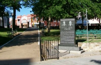
Location. 37° 52.59′ N, 94° 1.332′ W. Marker is in El Dorado Springs, Missouri, in Cedar County. Marker is in City Park, about 150 feet southwest of the intersection of Main Street (Missouri Route 82) and Spring Street. Touch for map. Marker is in this post office area: El Dorado Springs MO 64744, United States of America. Touch for directions.
Other nearby markers. At least 8 other markers are within walking distance of this marker. Roy Bandy and Eddy Wilson (a few steps from this marker); Prairie (a few steps from this marker); El Dorado Spring (within shouting distance of this marker); City Park Dedication (within shouting distance of this marker); Grindstone Wash Basin (within shouting distance of this marker); Former School Districts in El Dorado Springs R-2 (approx. 0.6 miles away); Veterans Memorial (approx. 0.6 miles away); Missouri Bicentennial Wagon (approx. 0.7 miles away). Touch for a list and map of all markers in El Dorado Springs.
Also see . . . City of El Dorado Springs Town History. City website entry (Submitted on July 10, 2012, by William Fischer, Jr. of Scranton, Pennsylvania.)
Credits. This page was last revised on April 28, 2022. It was originally submitted on July 10, 2012, by William Fischer, Jr. of Scranton, Pennsylvania. This page has been viewed 600 times since then and 24 times this year. Photos: 1, 2. submitted on July 10, 2012, by William Fischer, Jr. of Scranton, Pennsylvania.

