Manassas in Prince William County, Virginia — The American South (Mid-Atlantic)
Sudley Church
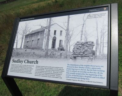
People were on their way to worship when thousands of Federal soldiers suddenly appeared marching south on Sudley Road. Within minutes the sound of gunfire came from the direction of Matthews Hill. As wounded men stumbled back behind the lines, Federals turned Sudley Church into a field hospital.
Hospital stewards removed the pews and procured hay for bedding. Harried surgeons used the altar for an operating table. Upwards of 300 wounded soldiers received treatment at the church. When the Union army retreated, six physicians remained behind to care for those who could not be moved. All were captured by Confederate cavalry at the battle's end.
The inhabitants of the neighborhood were out, dressed in their Sunday clothes, apparently preparing to go to church. But the little building was to witness no worship on that day. By the time usually assigned for the beginning of the service, it had become a hospital, and was filled with wounded and dying men.
- Captain Augustus Woodbury, 1st Rhode Island Infantry
Erected by Manassas National Battlefield Park - National Park Service - Department of the Interior.
Topics. This historical marker is listed in these topic lists: Churches & Religion • War, US Civil.
Location. 38° 50.332′ N, 77° 32.262′ W. Marker is in Manassas, Virginia, in Prince William County. Marker is on Sudley Road (State Highway 234), on the right when traveling south. Touch for map. Marker is in this post office area: Manassas VA 20109, United States of America. Touch for directions.
Other nearby markers. At least 8 other markers are within walking distance of this marker. Sudley (here, next to this marker); Battling for the Rocky Knoll (a few steps from this marker); “The Unfinished Railroad” (a few steps from this marker); Sudley Methodist Church (about 300 feet away, measured in a direct line); A Debt Repaid (about 500 feet away); Sudley Springs (approx. 0.2 miles away); Field Hospital (approx. 0.2 miles away); Thornberry House (approx. 0.2 miles away). Touch for a list and map of all markers in Manassas.
Also see . . . Church During Wartime. The old marker at this location. (Submitted on August 26, 2012, by Craig Swain of Leesburg, Virginia.)
Credits. This page was last revised on April 17, 2024. It was originally submitted on August 26, 2012, by Craig Swain of Leesburg, Virginia. This page has been viewed 871 times since then and 61 times this year. Photos: 1. submitted on August 26, 2012, by Craig Swain of Leesburg, Virginia. 2. submitted on September 11, 2015, by J. Makali Bruton of Accra, Ghana. 3, 4. submitted on August 26, 2012, by Craig Swain of Leesburg, Virginia.


