Near Manassas in Prince William County, Virginia — The American South (Mid-Atlantic)
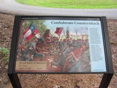
Confederate Counterattack
Second Battle of Manassas
— Day Three - August 30, 1862 - 4 p.m. —
Inscription.
Generals Robert E. Lee and James Longstreet both concluded the moment had arrived to launch a massive Confederate offensive at Second Manassas. Longstreet's wing of the army - nearly 30,000 troops - stood primed to sweep forward and sever the Union army's line of retreat. Their goal, ironically, was Henry Hill - the key terrain of the First Battle of Manassas.
Only three Federal brigades - fewer than 5,000 men - stood in their path. Following the bloody repulse at Deep Cut, other Federal troops had shifted north of the turnpike to restore order. This tactical blunder weakened the Union left, against which the Confederates now struck. John Pope's blindness to Longstreet's arrival had led to disaster.
Erected by Manassas National Battlefield Park - National Park Service - Department of the Interior.
Topics. This historical marker is listed in this topic list: War, US Civil.
Location. 38° 48.597′ N, 77° 32.684′ W. Marker is near Manassas, Virginia, in Prince William County. Marker is on New York Avenue, on the right when traveling south. Touch for map. Marker is in this post office area: Manassas VA 20109, United States of America. Touch for directions.
Other nearby markers. At least 8 other markers are within walking distance of this marker. 10th New York Vol. Infantry (within shouting distance of this marker); "The Very Vortex of Hell" (within shouting distance of this marker); 5th Regiment New York Volunteer Infantry (about 300 feet away, measured in a direct line); Twilight Clash (approx. 0.2 miles away); Fighting in Twilight (approx. 0.2 miles away); Brooklyn Fourteenth (approx. ¼ mile away); Federal Artillery Position (approx. ¼ mile away); New York Monuments (approx. ¼ mile away). Touch for a list and map of all markers in Manassas.
Credits. This page was last revised on June 16, 2016. It was originally submitted on August 27, 2012, by Craig Swain of Leesburg, Virginia. This page has been viewed 626 times since then and 9 times this year. Photos: 1, 2, 3. submitted on August 27, 2012, by Craig Swain of Leesburg, Virginia.


