Wickliffe in Ballard County, Kentucky — The American South (East South Central)
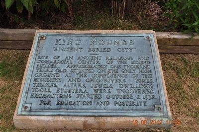
King Mounds
"Ancient Buried City"
Topics. This historical marker is listed in these topic lists: Anthropology & Archaeology • Cemeteries & Burial Sites • Native Americans. A significant historical date for this entry is October 2, 1935.
Location. 36° 58.248′ N, 89° 5.554′ W. Marker is in Wickliffe, Kentucky, in Ballard County. Marker can be reached from Green Street (U.S. 60) west of 1st Street, on the right when traveling west. Touch for map. Marker is at or near this postal address: 94 Green St, Wickliffe KY 42087, United States of America. Touch for directions.
Other nearby markers. At least 8 other markers are within walking distance of this marker. Welcome to Wickliffe Mounds (a few steps from this marker); Ceremonial Mound (within shouting distance of this marker); Burial Mound (within shouting distance of this marker); The Prince of the French Explorers (about 400 feet away, measured in a direct line); Private First Class Robert Monroe Hammonds (approx. 0.4 miles away); County Named, 1842 (approx. 0.4 miles away); Lewis & Clark at Old Fort Jefferson (approx. 0.9 miles away); Fort Jefferson Memorial Cross at the Confluence (approx. 0.9 miles away). Touch for a list and map of all markers in Wickliffe.
Credits. This page was last revised on October 5, 2020. It was originally submitted on August 28, 2012, by Sandra Hughes Tidwell of Killen, Alabama, USA. This page has been viewed 990 times since then and 91 times this year. Photos: 1. submitted on August 28, 2012, by Sandra Hughes Tidwell of Killen, Alabama, USA. 2. submitted on September 7, 2012, by Sandra Hughes Tidwell of Killen, Alabama, USA. • Bernard Fisher was the editor who published this page.
Editor’s want-list for this marker. Wide shot of marker and its surroundings. • Can you help?

