Fayetteville in Washington County, Arkansas — The American South (West South Central)
Evolution of Fayetteville
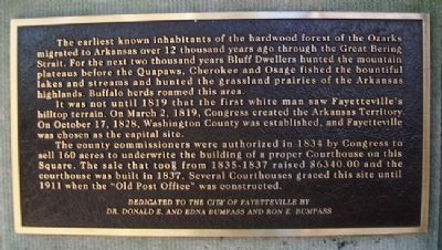
The earliest known inhabitants of the hardwood forest of the Ozarks migrated to Arkansas over 12 thousand years ago through the Great Bering Strait. For the next two thousand years Bluff Dwellers hunted the mountain plateaus before the Quapaws, Cherokee and Osage fished the bountiful lakes and streams and hunted the grassland prairies of the Arkansas highlands. Buffalo herds roamed this area.
It was not until 1819 that the first white man saw Fayetteville’s hilltop terrain. On March 2, 1819, Congress created the Arkansas Territory. On October 17, 1828, Washington County was established, and Fayetteville was chosen as the capital site.
The county commissioners were authorized in 1834 by Congress to sell 160 acres to underwrite the building of a proper Courthouse on this Square. The sale that took from 1835-1837 raised $6340.00 and the courthouse was built in 1837. Several Courthouses graced this site until 1911 when the “Old Post Office” was constructed.
Dedicated to the City of Fayetteville by
Dr. Donald E. and Edna Bumpass and Ron E. Bumpass
Erected by Dr. Donald E. and Edna Bumpass and Ron E. Bumpass.
Topics. This historical marker is listed in these topic lists: Environment • Native Americans • Settlements & Settlers. A significant historical date for this entry is March 2, 1819.
Location. 36° 3.744′ N, 94° 9.607′ W. Marker is in Fayetteville, Arkansas, in Washington County. Marker is at the intersection of Center Street and East Avenue, on the left when traveling west on Center Street. Marker is on the Downtown Square. Touch for map. Marker is in this post office area: Fayetteville AR 72701, United States of America. Touch for directions.
Other nearby markers. At least 8 other markers are within walking distance of this marker. Significant Dates in Fayetteville History (here, next to this marker); Fayetteville Center Square (here, next to this marker); Mrs. Young Block (within shouting distance of this marker); Lewis Brothers Building (within shouting distance of this marker); First Confederate Company Organized in Washington County (within shouting distance of this marker); Guisinger Building (about 300 feet away, measured in a direct line); Fayetteville's Earliest Methodist Church (about 400 feet away); Reiff House (about 700 feet away). Touch for a list and map of all markers in Fayetteville.
Credits. This page was last revised on September 14, 2020. It was originally submitted on September 29, 2012, by William Fischer, Jr. of Scranton, Pennsylvania. This page has been viewed 479 times since then and 16 times this year. Photos: 1, 2. submitted on September 29, 2012, by William Fischer, Jr. of Scranton, Pennsylvania.

