Kiilhsoohkwa (Kilsoquah)
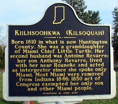
(Front Side)
Born 1810 in what is now Huntington County. She was a granddaughter of Miami Chief Little Turtle. Her second husband was Antoine Revarre; her son Anthony Revarre, lived with her near Roanoke and acted as interpreter since she spoke only Miami. Most Miami were removed from Indiana 1846; 1850 act of Congress exempted her only son and other Miami people.
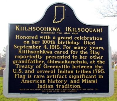
(Back Side)
Honored with a grand celebration on her 100th birthday. Died September 4, 1915. For many years, Kiilhsoohkwa cared for the flag reportedly presented to her other grandfather, šhimaakanehsia, at the Treaty of Greenville between the U.S. and several Indian tribes 1795. Flag is rare artifact significant in American history and Miami Indian tradition.
Erected 2005 by Indiana Historical Bureau, Roanoke Area Heritage Center, Inc., and Miami Nation - Miami, Oklahoma. (Marker Number 35.2005.1.)
Topics and series. This historical marker is listed in these topic lists: Cemeteries & Burial Sites • Indigenous Peoples and Communities. In addition, it is included in the Indiana Historical Bureau Markers series list. A significant historical date for this entry is September 4, 1915.
Location. 40° 58.34′ N,
this page online

Regionally, this marker is in Northern Indiana. It is also in the American Midwest and in the Corn Belt. Globally, it is in North America, the Western Hemisphere, the Western World, and the Anglosphere. Historically, it finds itself in what was once the territory of the Mississippian Culture and also the Northwest Territory.
Other nearby markers. At least 8 other markers are within 9 miles of this marker, measured as the crow flies: Wabash & Erie Canal Lock 4 (approx. ¾ mile away); The Hartleys (approx. ¾ mile away); The Little River Valley Story (approx. 7.9 miles away); The Towpath Trail History (approx. 8.1 miles away); Lost Birds of Canal Days (approx. 8.1 miles away); Fred A. Loew (approx. 8.2 miles away); a different marker also named Fred A. Loew (approx. 8.2 miles away); Huntington County Civil War Memorial
Also see . . . IHB Annotations. The Indiana Historical Bureau provides annotations for the text of the marker on their website. (Submitted on December 12, 2013.)
Credits. This page was last revised on June 16, 2016. It was originally submitted on November 15, 2012, by Duane Hall of Abilene, Texas. This page has been viewed 1,364 times since then and 37 times this year. Photos: 1, 2, 3, 4. submitted on November 15, 2012, by Duane Hall of Abilene, Texas. • Bill Pfingsten was the editor who published this page.
