Scotland in St. Mary's County, Maryland — The American Northeast (Mid-Atlantic)
Storm Blocks the Route to Freedom
Point Lookout State Park
| — | Maryland Park Service | — |
Photographed by Allen C. Browne, January 7, 2013
1. Storm Blocks the Route to Freedom Marker
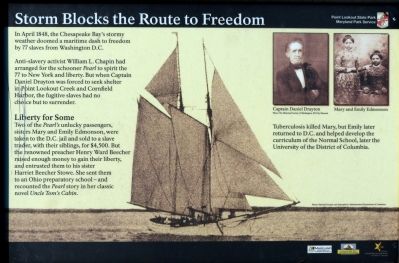
In April 1848, the Chesapeake Bay's stormy weather doomed a maritime dash to freedom by 77 slaves from Washington D.C.
Anti-slavery activist William L. Chapin had arranged for the schooner Pearl to spirit the 77 to New York and liberty. But when Captain Daniel Drayton was forced to seek shelter in Point Lookout Creek and Cornfield Harbor, the fugitive slaves had no choice but to surrender.
Liberty for Some
Two of the Pearl's unlucky passengers, sisters Mary and Emily Edmonson, were taken to the D. C. jail and sold to a slave trader, with their siblings, for $4,500. But the renowned preacher Henry Ward Beecher raised enough money to gain their liberty, and entrusted them to his sister Harriet Beecher Stowe. She sent them to an Ohio preparatory school -- and recounted the Pearl story in her classic novel Uncle Tom's Cabin.
Tuberculosis killed Mary, but Emily later returned to D. C., and helped develop the curriculum of the Normal School, later the University of the District of Columbia.
Erected by Maryland Park Service.
Topics and series. This historical marker is listed in these topic lists: Abolition & Underground RR
this page online
Location. 38° 3.119′ N, 76° 19.627′ W. Marker is in Scotland, Maryland, in St. Mary's County. It is on Point Lookout Road (Maryland Route 5). Marker is at the Lake Canoy inlet near the fish cleaning station in Point Lookout State Park at the end of Point Lookout Road (MD 5). Touch for map. Marker is in this post office area: Scotland MD 20687, United States of America. Touch for directions.

Regionally, this marker is in Southern Maryland. It is also in the American South, specifically in the Upper South, in the Mid-Atlantic, in the Tidewater, in the Chesapeake Bay Region, and on the Eastern Seaboard. Globally, it is in the North Atlantic Region, North America, the Western Hemisphere, the Western World, and the Anglosphere. Historically, it finds itself in what was once one of the original Thirteen Colonies and also the Antebellum South.
Other nearby markers. At least 8 other markers are within walking distance of this marker: The Armaments of Point Lookout

Photographed by Allen C. Browne, January 7, 2013
2. Storm Blocks the Route to Freedom Marker
Another marker is no longer nearby. Prison Pen (was approx. ¼ mile away but has been replaced with another marker now near it).
Additional keywords. UDC
Photographed by Allen C. Browne, January 7, 2013
3. Storm Blocks the Route to Freedom Marker
Credits. This page was last revised on April 12, 2026. It was originally submitted on January 7, 2013, by Allen C. Browne of Silver Spring, Maryland. This page has been viewed 812 times since then and 29 times this year. Last updated on January 12, 2013, by Allen C. Browne of Silver Spring, Maryland. Photos: 1, 2, 3. submitted on January 7, 2013, by Allen C. Browne of Silver Spring, Maryland. • Craig Swain was the editor who published this page.
