Hermann in Gasconade County, Missouri — The American Midwest (Upper Plains)
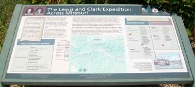
The Lewis and Clark Expedition Across Missouri
Inscription.
"as we were pushing off this Morning two Canoes Loaded with fur &c. Came to from the Mahars nation [Omahas]...., at about 10 oClock 4 Cajaux or rafts loaded with furs and peltres came too one from the Paunees (Pawnees) the other from Grand Osage... we camped on a Willow Island in the mouth of Gasconade River"
William Clark, May 27, 1804
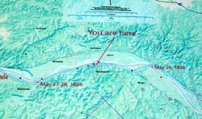
On May 26, 1804, the Lewis and Clark Expedition camped on an island at the southern end of Loutre Ialand near present-day Hermann. The party had made some 18 miles on this day aided by a wind that gave them a rare chance to use the sail on the keelboat. Along the way, they noted many signs of deer along the bank.
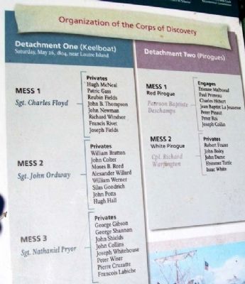
While encamped, Captain Meriwhether Lewis issued a set of Detachment Orders dividing the 24 man crew of the keelboat (all enlisted privates in the army) into three messes under the command of Sergeants Floyd, Ordway and Pryor. These three messes contained the elite corps of men who were designated by the captains to make the entire journey to the Pacific Ocean and back. The crew of hired French boatmen, or engagιs, assigned to the red pirogue formed a mess under the Patroon, Bapiste Deschamps. They returned to St. Louis from Fort Mandan in the spring of 1805. Another mess, consisting of army personnel under the command of Cpl. Richard Warfington, formed the crew of the white pirogue. Warfington and the crew of the white pirogue were to pilot the keelboat back to St. Louis from Fort Mandan in the spring of 1805 along with reports from the captains and specimens collected on the expedition; these were to be forwarded to President Thomas Jefferson.
The next day (May 27), the expedition encountered several canoes and boatloads of traders. Some of these had come down from the Omaha Indian nation about 700 miles upriver; some had come down from the Pawnee nation on the Platte River; and some had come down from the Grand Osage village on the Osage River. Sometime on the morning of May 27, the expedition passed the site of present-day Hermann and then continued on to the mouth of the Gasconade River where they stayed through May 28.
Duties of Sergeants on Keelboats
Sgt. at the Helm
Steer boat See that baggage arranged and stowed Attend to compass
Sgt. at the Center
Command guard Manage sails Supervise oarsmen See that boat departs on time Watch for streams, islands Issue "spirituous liquor" Regulate halts Post guards on land
Sgt. at Bow
Look out for all dangers: enemy or obstruction Communicate same to Sgt. at Center Report all other craft, hunting camps, Indians Assist bowman in poling
Organization of the Corps of Discovery
Detachment
One (Keelboat)
Saturday, May 26, 1804, near Loutre Island
Mess 1, Sgt. Charles Floyd
Privates Hugh McNeal Patric Gass Reubin Fields John B. Thompson John Newman Richard Windsor Francis Rivet Joseph Fields
Mess 2, Sgt. John Ordway
Privates William Bratton John Colter Moses B. Reed Alexander Willard William Werner Silas Goodrich John Potts Hugh Hall
Mess 3, Sgt. Nathaniel Pryor
Privates George Gibson George Shannon John Shields John Collins Joseph Whitehouse Peter Wiser Pierre Cruzatte Francois Labiche
Detachment Two (Pirogues)
Mess 1, Red Pirogue, Patroon Baptiste Deschamps
Engages Etienne Malboeuf Paul Primeau Charles Hebert Jean Baptist La Jeunesse Peter Pinaut Peter Roi Joseph Collin
Mess 2, White Pirogue, Cpl. Richard Warfington
Privates Robert Frazer John Boley John Dame Ebinezer Tuttle Issac White
Erected by National Park Service, Missouri Dept of Natural Resources, and Missouri Lewis and Clark Bicentennial Commission.
Topics and series. This historical marker is listed in these topic lists: Exploration • Industry & Commerce • Native Americans
Photographed By Gary R. Lucy, undated
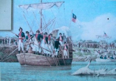
3. Painting on The Lewis and Clark Expedition Across Missouri Marker
[Caption reads] This painting of the departure of the Lewis and Clark Expedition from St. Charles, by Washington, Mo., artist Gary R. Lucy, depicts the army soldiers of the expedition attired in their formal uniforms. These uniforms have the distinctive styles of the infantry and artillery units from which the men were detached to join the expedition. Courtesy of Gary R. Lucy Gallery
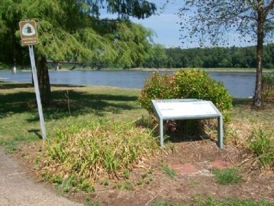
Location. 38° 42.47′ N, 91° 25.918′ W. Marker is in Hermann, Missouri, in Gasconade County. Marker is in Riverfront Park, accessed off Wharf Street. Touch for map. Marker is in this post office area: Hermann MO 65041, United States of America. Touch for directions.
Other nearby markers. At least 8 other markers are within walking distance of this marker. Voyage of Discovery (here, next to this marker); Pioneer Trails Juncture (a few steps from this marker); 232 Wharf St. (about 400 feet away, measured in a direct line); The Caboose Museum (about 400 feet away); Monnig Family General Store (about 500 feet away); Hermann (about 500 feet away); The Wohlt House (about 800 feet away); The Concert Hall and Barrel Bar (approx. 0.2 miles away). Touch for a list and map of all markers in Hermann.
Also see . . .
1. Lewis and Clark National Historic Trail. (Submitted on February 10, 2013, by William Fischer, Jr. of Scranton, Pennsylvania.)
2. Lewis and Clark Across Missouri. (Submitted on February 10, 2013, by William Fischer, Jr. of Scranton, Pennsylvania.)
3. Lewis and Clark in Missouri. (Submitted on February 10, 2013, by William Fischer, Jr. of Scranton, Pennsylvania.)
Credits. This page was last revised on May 1, 2022. It was originally submitted on February 10, 2013, by William Fischer, Jr. of Scranton, Pennsylvania. This page has been viewed 803 times since then and 31 times this year. Photos: 1, 2, 3, 4, 5. submitted on February 10, 2013, by William Fischer, Jr. of Scranton, Pennsylvania.
