Vienna in Dorchester County, Maryland — The American Northeast (Mid-Atlantic)
Discover: Vienna
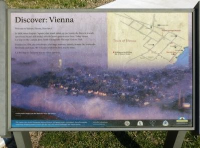
Welcome to Vienna, Maryland
In 1608, when English Captain John Smith sailed up the Nanticoke River in a small, open boat, he met and traded with the native people near here. Today Vienna is a stop on the Captain John Smith Chesapeake National Historic Trail.
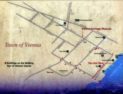
Founded in 1706, the town boasts a heritage museum, historic homes, the Nanticoke Riverwalk and more. We welcome visitors by land and water. See the map to find your way to the visitor services.
Topics and series. This historical marker is listed in these topic lists: Colonial Era • Exploration • Native Americans • Settlements & Settlers • Waterways & Vessels. In addition, it is included in the Captain John Smith Chesapeake National Historic Trail series list. A significant historical year for this entry is 1608.
Location. 38° 28.98′ N, 75° 49.399′ W. Marker is in Vienna, Maryland, in Dorchester County. Marker is on Water Street, on the right when traveling north. Touch for map. Marker is in this post office area: Vienna MD 21869, United States of America. Touch for directions.
Other nearby markers. At least 8 other markers are within 2 miles of this marker, measured as the crow flies. Discover: The Nanticoke (here, next to this marker); Discover: Restoration (a few steps from this marker); A walking tour of Vienna (within shouting distance of this marker); Discover: The Shoreline (about 400 feet away, measured in a direct line); John Smith Explores the Chesapeake (approx. 0.2 miles away); Discover: Vienna Heritage (approx. ¼ mile away); Unnacokossimmon (approx. 0.4 miles away); The Nanticoke Historic Preservation Alliance (approx. 1.9 miles away). Touch for a list and map of all markers in Vienna.
Credits. This page was last revised on January 15, 2022. It was originally submitted on February 14, 2013, by Allen C. Browne of Silver Spring, Maryland. This page has been viewed 383 times since then and 14 times this year. Photos: 1, 2, 3, 4. submitted on February 14, 2013, by Allen C. Browne of Silver Spring, Maryland. • Bill Pfingsten was the editor who published this page.


