Stigler in Haskell County, Oklahoma — The American South (West South Central)
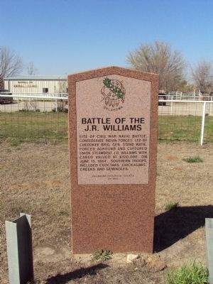
Battle of the J.R. Williams
Erected 1995 by Oklahoma Historical Society. (Marker Number 69.)
Topics and series. This historical marker is listed in these topic lists: Native Americans • War, US Civil • Waterways & Vessels. In addition, it is included in the Oklahoma Historical Society series list. A significant historical month for this entry is June 1857.
Location. 35° 15.654′ N, 95° 3.756′ W. Marker is in Stigler, Oklahoma, in Haskell County. Marker is at the intersection of State Highway 9 and Garland-Tamaha Road, on the right when traveling west on State Highway 9. Marker is located approximately 50 yards west of Garland-Tamaha Road on SR 9. Actual location of the J.R. Williams capture and sinking is approximately 10 miles northeast on the Canadian River near the town of Tamaha. Touch for map. Marker is in this post office area: Stigler OK 74462, United States of America. Touch for directions.
Other nearby markers. At least 5 other markers are within 11 miles of this marker, measured as the crow flies. Tamaha Jail and Ferry Landing (here, next to this marker); In Memory of the Early Choctaw Settlers (approx. 3˝ miles away); Haskell County World War Memorial (approx. 3˝ miles away); Unmarked Settlers' Graves Monument (approx. 3˝ miles away); a different marker also named Tamaha Jail and Ferry Landing (approx. 10˝ miles away).
Credits. This page was last revised on June 16, 2016. It was originally submitted on April 1, 2013, by Michael Manning of Woodlawn, Tennessee. This page has been viewed 1,542 times since then and 77 times this year. Photo 1. submitted on April 1, 2013, by Michael Manning of Woodlawn, Tennessee. • Craig Swain was the editor who published this page.
Editor’s want-list for this marker. A photo of the marker and the surrounding area in context. • Can you help?
