Yorktown in York County, Virginia — The American South (Mid-Atlantic)
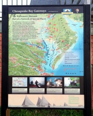
The Watermen's Museum
Part of a Network of Special Places
— Chesapeake Bay Gateways —
Chesapeake Bay Facts:
• 2,500 sq. miles of water
• Width: 3.4 to 35 miles
• Approximately 11,684 miles of shoreline
• Average depth – 21 feet; maximum depth 174 feet
• Largest of the 130 estuaries (a place where salt and fresh water intermix) in the United States
• Watershed drains 64,000 sq. miles of land in 5 states
• The estuary supports more than 3,600 species of plants and animals
While in the area visit nearby Gateway sites to learn even more stories about the Chesapeake Bay.
Watermen fishing the Bay
The Chesapeake Bay is filled with maritime lore. Watermen still head out in pre-dawn darkness to harvest the Bay’s bounty.
Osprey
Millions of waterfowl make their way along the Bay and through its watershed every year. Witness these migrations and countless other natural wonders.
Yorktown Battlefield
At Gateway sites like Yorktown Battlefield history comes alive. The Bay provided the background for events that created our nation.
Erected by National Park Service.
Topics. This historical marker is listed in this topic list: Natural Features.
Location. 37° 14.375′ N, 76° 30.639′ W. Marker is in Yorktown, Virginia, in York County. Marker can be reached from Water Street west of Buckner Street, on the right when traveling west. Located along Yorktown's Riverwalk. Touch for map. Marker is at or near this postal address: 309 Water Street, Yorktown VA 23690, United States of America. Touch for directions.
Other nearby markers. At least 8 other markers are within walking distance of this marker. Join the Adventure (here, next to this marker); Aviation Field Yorktown (a few steps from this marker); Yorktown's Windmill (a few steps from this marker); John Smith Explores the Chesapeake (a few steps from this marker); The Betsy (within shouting distance of this marker); Naval Weapons Station (within shouting distance of this marker); The Yorktown Windmill (within shouting distance of this marker); Chesapeake Bay Watermen (about 300 feet away, measured in a direct line). Touch for a list and map of all markers in Yorktown.
Also see . . . The Watermen's Museum. (Submitted on April 21, 2013.)
Credits. This page was last revised on November 14, 2021. It was originally submitted on April 21, 2013, by Bernard Fisher of Richmond, Virginia. This page has been viewed 335 times since then and 13 times this year. Photos: 1, 2. submitted on April 21, 2013, by Bernard Fisher of Richmond, Virginia.

