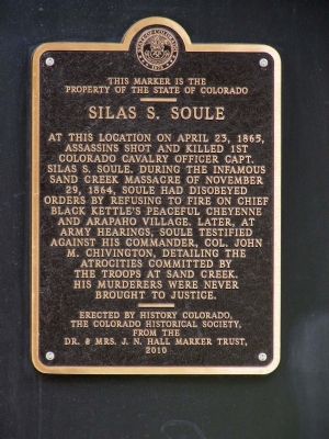
Central Business District in Denver in Denver County, Colorado — The American Mountains (Southwest)
Silas S. Soule
Erected 2010 by The Colorado Historical Society.
Topics and series. This historical marker is listed in these topic lists: Military • Native Americans • Wars, US Indian. In addition, it is included in the Colorado - History Colorado series list. A significant historical month for this entry is April 1925.
Location. 39° 44.835′ N, 104° 59.826′ W. Marker is in Denver, Colorado, in Denver County. It is in the Central Business District. Marker can be reached from 15th Street near Arapahoe Street, on the right when traveling west. The marker is 100 feet from 15th Street and about 100 feet from Arapahoe Street behind a black pillar supporting the building. Touch for map. Marker is at or near this postal address: 1500 Arapahoe Street, Denver CO 80211, United States of America. Touch for directions.
Other nearby markers. At least 8 other markers are within walking distance of this marker. Larimer Street (about 600 feet away, measured in a direct line); Denver's Old City Hall (approx. 0.2 miles away); Lynching in America / The Lynching of Preston Porter, Jr. (approx. 0.2 miles away); D&F Tower and Skyline Park (approx. 0.2 miles away); Coal Miner's Daughter (approx. 0.2 miles away); Rails and Mountains (approx. 0.2 miles away); All Washed Up (approx. 0.2 miles away); Private Profits and the Public Good (approx. 0.2 miles away). Touch for a list and map of all markers in Denver.
Credits. This page was last revised on February 7, 2023. It was originally submitted on July 29, 2013, by Marvin Seibert of Ketchikan, Alaska. This page has been viewed 1,375 times since then and 63 times this year. Photo 1. submitted on July 29, 2013, by Marvin Seibert of Ketchikan, Alaska. • Syd Whittle was the editor who published this page.
Editor’s want-list for this marker. Wide area view of the marker and its surroundings. • Can you help?
