Stafford in Stafford County, Virginia — The American South (Mid-Atlantic)
Union Army Double-Track Corduroy Road
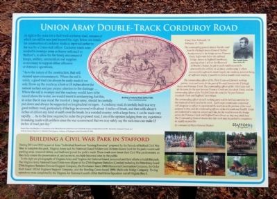
“As to the nature of the construction, that will depend upon circumstances. Where the soil is sandy, a good road can always be easily made if we only throw up the roadway a foot or 18 inches above the natural surface and pay proper attention to the drainage. …Where the soil is swampy and the roadway would have to he raised above the water, we would resort to corduroying, but this, in order that it may stand the travel of a large army, should be carefully put down and always be supported on longitudinal stringers. A corduroy road, if carefully built is a very good military road, particularly if the logs be covered with about 6 inches of brush, and then with about 6 inches of almost any kind of earth over the brush. In a wooded country, with a large force, it can be made very rapidly… As to the time required to make the proposed road, I am of the opinion judging from my experience in making roads with soldiers since the war commenced that we may safely say the each man can make 15 inches of road per day.”
Source: War of the Rebellion: A Compilation of the Official Records of the Union and Confederate Armies; correspondence from B.S. Alexander, Lieutenant Colonel, and Aide-de-Camp to Brig. Gen. J.G. Barnard, Chief Engineer, Defense of Washington, dated November 27, 1862.
Camp Near Falmouth, VA
February 15, 1863
The commanding general directs that the road from the Fitzhugh house (General Sickles’ headquarters) to the bridge across Potomac Creek, half a mile below the railroad bridge, thence to Stafford Courthouse, passing about 1 mile to the westward of Brooke’s Station, be put in such condition as to be practicable for artillery at all times, corduroying it where necessary throughout its whole length; the corduroy material being of sufficient length, if possible, to form a double-track road way.
The commanding officer of the Third Corps will furnish working parties, tools, and teams for the part of the road between the Fitzhugh house and Potomac Creek. The commanding officer of the 11th Corps will do the same for the part between Potomac Creek and Accakeek Creek, and the commanding officer of the Twelfth Corps the same for the part between Accakeek Creek and Stafford Court-House.
The commanding officer of each working party will be held accountable for the return of all tools used in the work. Each corps commander concerned will designate an officer to superintend the work upon the portion of the road assigned to him, and the commanding officers of the Eleventh and Twelfth Corps are authorized to select in concert such line for the road between the bridge across the Potomac Creek and Stafford Court-House as they may think best. The commanding general desires that this work may be pushed to completion as rapidly as possible.
By command of Major-General Hooker:
(sidebar)
Building a Civil war park in Stafford
During 2011 and 2012 as part of three “Individual Readiness Training Exercises” proposed by the Friends of Stafford Civil War Sites to complete this park, Virginia Army and Air National Guard Soldiers and Airmen cleared land for the park’s roads and parking areas, removed debris, arid built and paved the park’s roads. These roads now honor their Civil War predecessors, as they help ensure the preservation of, and access to, multiple historical sites by the public.
To the right are photographs of Virginia Army and Virginia Air National Guard personnel and their efforts to build this park. The Virginia Army National Guard Units were all part of the 276th Engineer Battalion (Combat) including the Petersburg-based 276th Engineer Battalion Forward Support, the Powhatan- based 180th Horizontal Construction Company, the Cedar Bluff- based 1033rd Engineer Support Company, and the Bowling Green-based 189th Multi-role Bridge Company. Paving operations were completed by the Virginia Air National Guard’s 203rd Red Horse Squadron out of Virginia Beach.
(captions)
Building a corduroy road, Stafford 1863 Arthur Lumley/National Archives
General Joseph Hooker Harpers Weekly, 1863
July 2011
July 2012
August 2012
Erected 2013 by Stafford County.
Topics. This historical marker is listed in these topic lists: Roads & Vehicles • War, US Civil. A significant historical month for this entry is February 1863.
Location. 38° 23.523′ N, 77° 24.505′ W. Marker is in Stafford, Virginia, in Stafford County. Marker can be reached from Mount Hope Church Road (County Route 677) 1.2 miles west of Brooke Road (County Route 608). Located in Stafford Civil War Park. Touch for map. Marker is at or near this postal address: 400 Mount Hope Church Rd, Stafford VA 22554, United States of America. Touch for directions.
Other nearby markers. At least 8 other markers are within walking distance of this marker. 11th Corps Road (a few steps from this marker); German-Americans and the Eleventh Corps (a few steps from this marker); Union Battery (a few steps from this marker); a different marker also named Union Battery (about 800 feet away, measured in a direct line); Sandstone Quarry (approx. ¼ mile away); Quarrying the Stone (approx. ¼ mile away); Potomac Church Road (approx. 0.3 miles away); Union Eleventh Corps Artillery (approx. 0.3 miles away). Touch for a list and map of all markers in Stafford.
Also see . . . Stafford Civil War Park. (Submitted on November 25, 2013.)
Credits. This page was last revised on May 24, 2022. It was originally submitted on November 25, 2013, by Bernard Fisher of Richmond, Virginia. This page has been viewed 731 times since then and 40 times this year. Photos: 1, 2, 3. submitted on November 25, 2013, by Bernard Fisher of Richmond, Virginia.


