Danbury in Fairfield County, Connecticut — The American Northeast (New England)
Kenosia & Candlewood
Danbury, Connecticut
— The Museum in the Streets® —
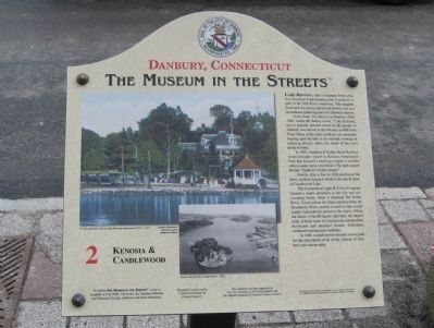
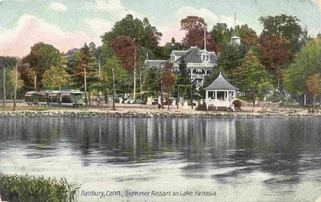
Lake Kenosia, said to originate from a Native American word meaning pike or pickerel, is part of the Still River waterway. This popular local park has always played an historic role as a recreational gathering place for Danbury residents.
In his book, The History of Danbury 1684-1896, James M. Bailey wrote, “Lake Kenosia, now a popular summer resort for the people of Danbury was known in the old days as Mill Plain Pond. Many of the older residents can remember boating upon the lake in the moonlit evenings or enjoying picnics under the shade of the trees along its bank.”
In 1895, Danbury & Bethel Street Railway tracks brought visitors to Kenosia Amusement Park that boasted a merry-go-round, a wooden roller coaster and a resort hotel. The park earned the title “Danbury’s Coney Island.”
Shortly after a fire in 1926 destroyed the hotel, residents began to flock to the newly created Candlewood Lake.
The Connecticut Light & Power Company created a major attraction in the city and surrounding towns when it dammed the Rocky River. Construction of a huge pipeline from the Housatonic River created a reservoir that would supply hydroelectric power to the region. Along the shores of the 80-square mile lake, the largest body of fresh water in Connecticut, communities developed and attracted boaters, fisherman, swimmers and summer residents.
In 1948, a small section became a town park for the enjoyment of all the citizens of Danbury and visitors alike.
Erected by The Museum in the Streets®. (Marker Number 2.)
Topics and series. This historical marker is listed in these topic lists: Parks & Recreational Areas • Waterways & Vessels. In addition, it is included in the The Museum in the Streets®: Danbury, Connecticut series list. A significant historical year for this entry is 1895.
Location. 41° 23.645′ N, 73° 27.123′ W. Marker is in Danbury, Connecticut, in Fairfield County. Marker is at the intersection of Main Street and West Street, on the right when traveling south on Main Street. Touch for map. Marker is at or near this postal address: 198 Main Street, Danbury CT 06810, United States of America. Touch for directions.
Other nearby markers. At least 8 other markers are within walking distance of this marker. The Settling of Danbury (within shouting distance of this marker); Savings Bank of Danbury at Bankers’ Row (within shouting distance of this marker); War Memorial (within shouting distance of this marker); To Our Brothers (within shouting distance of this marker); Danbury Women of Note (about 300 feet away, measured in a direct line); Danbury Firsts (about 300 feet away); Old City Center Square (about 300 feet away); Danbury – The Hat City (about 400 feet away). Touch for a list and map of all markers in Danbury.
Also see . . .
1. Candlewood Lake on Wikipedia. (Submitted on January 12, 2014, by Michael Herrick of Southbury, Connecticut.)
2. Still River (Housatonic River) on Wikipedia. (Submitted on January 12, 2014, by Michael Herrick of Southbury, Connecticut.)
Credits. This page was last revised on November 25, 2021. It was originally submitted on January 12, 2014, by Michael Herrick of Southbury, Connecticut. This page has been viewed 849 times since then and 25 times this year. Photos: 1, 2. submitted on January 12, 2014, by Michael Herrick of Southbury, Connecticut. 3. submitted on October 24, 2015.


