Springfield in Fairfax County, Virginia — The American South (Mid-Atlantic)
The Origins of Lake Accotink
Photographed by J. J. Prats, April 5, 2008
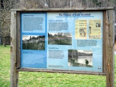
1. The Origins of Lake Accotink Marker
Indigenous People. The original inhabitants of the lands around Accotink Creek lived as semi-sedentary hunters and gatherers who moved seasonally to fallow game. These peoples spoke varying forms of the Algonquin language. The river system provided them with a wealth of resources as well as a means of transportation. The waters teemed with fish and deer and other animals were drawn to its banks. Gathering and farming were also important lifeways. Corn and beans were combined as “succotash” making up half their diet, which was also supplemented with wild berries and nuts. Early peoples were also drawn to the area due to the prolific amount of quartz and other materials from which they could make tools, including projectile points and stone scrapers. With European advancement along the waterways beginning in the early 17th century, the Native Americans were slowly pushed off their lands.
Bridging the Gap. The railroad trestle was built as part of the Orange and Alexandria Railroad in 1851. The line connected the port city of Alexandria with the interior of the state, which allowed for a more efficient exchange of raw
this page online
Camp A. A. Humphreys. In 1912, the War Department purchased a plot of land that had once been part of the Belvoir estate built by William Fairfax in 1741. The land was meant to serve as a summer camp and rifle range for the engineering corps stationed at nearby Washington Barracks in Washington, DC. With the outbreak of WWI, the camp was turned into a more permanent establishment and named Camp A. A. Humphreys, after a distinguished Civil War engineer. With plans to permanently move the Army Corps of Engineers there in 1919, a water source was needed.
Springfield Dam. Originally known as the Springfield Dam, when it was first built in 1918, the dam created Lake Accotink
Photographed by J. J. Prats, April 5, 2008
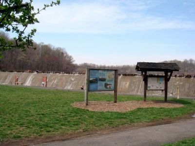
2. Marker on the Left. Bulletin Board on the Right.
Lake Accotink Dam is in the background. The railroad bridge is overhead.
With the development of Springfield during the 1950s, Fort Belvoir opted to move its water source to the Alexandria Water Company. With Lake Accotink no longer needed for a water source, military officers used it as a retreat until the Fairfax County Park Authority leased in in 1960. The part Authority purchased the land for half price in 1965 under the federal “Land to Parks” program.
This display was developed in 2003 by Lake Accotink Park staff to enhance awareness about the noteworthy role that Lake Accotink and the surrounding land played in local history.
Topics. This historical marker is listed in these topic lists: Military • Parks & Recreational Areas • Railroads & Streetcars • Waterways & Vessels. A significant historical date for this entry is December 28, 1862.
Location. Marker has been reported missing. It was located near 38° 47.586′ N, 77° 13.076′ W. Marker was in Springfield, Virginia, in Fairfax County. It was on Accotink Park Road east of Southern Drive, on the right when traveling west. From Backlick Road (County Route 617), take Highland Street west to Accotink Park Road on the right. Accotink Park Road jogs to the left (follow the signs to the park) while Southern Drive continues straight ahead. Marker is at the parking lot under the railroad bridge. Touch for map. Marker was in this post office area: Springfield VA 22151, United States of America. Touch for directions.

Regionally, this marker was in the Washington Metropolitan Area and in Northern Virginia. It was also in the American South, specifically in the Upper South, in the Mid-Atlantic, and on the Eastern Seaboard. Globally, it was in the North Atlantic Region, North America, the Western Hemisphere, the Western World, and the Anglosphere. Historically, it found itself in what was once the territory of the Mississippian Culture, one of the original Thirteen Colonies, one of the Confederate States of America, and the Antebellum South.
Other nearby markers. At least 8 other markers are within 2 miles of this location, measured as the crow flies: Connecting Communities and Parks (a few steps from this marker); Orange and Alexandria Railroad (within shouting distance of this marker); The Civilian Conservation Corps (approx. 0.4 miles away); a different marker also named Orange and Alexandria Railroad (approx. 0.7 miles away); Ravensworth (approx. 1.1 miles away); a different marker also named Ravensworth (approx. 1.2 miles away); Estate Inventory of 16 Enslaved, December 20, 1856 (approx. 1.2 miles away); Soldiers Memorial at Howrey Field Park (approx. 1½ miles away). Touch for a list and map of all markers in Springfield.
Other markers no longer nearby. The Orange And Alexandria Railroad Trestle (was within shouting distance of this marker but has been confirmed missing); Orange and Alexandria RR (was within shouting distance of this marker but has been confirmed missing).
More about this marker. Marker has three photographs and a reproduction of two newspaper pages. The caption on the left-most photograph reads “The wooden railroad trestle over Accotink Creek made an attractive target to Confederate raiders seeking to disrupt Union supply lines.” Center photograph shows dam building in progress: “Accotink Creek provided an ideal location for a water source because of its relatively short distance upstream from Camp A. A. Humphreys situated between Route 1 and the Potomac River. The photograph on the lower right of the marker has this caption: “Because the first dam threatened the integrity of the railroad bridge, it was dismantled in 1922. In 1943, the Army Corp of Engineers rebuilt the dam for $19,000.” On the upper right a reproduction of the front and inside page of the January 11, 1946 issue Belvoir Castle newspaper has illustrated article on the dam and lake entitled “4,000,000 Gallon Thirst Keep Water Crew Busy.”
Also see . . . Historic Lake Accotink Park. This website includes a review of historical markers in the park, notes on other points of historical interest, and a catalog of artifacts housed in the park's visitors center. There are also links to additional information about the park and a gallery of images submitted by local citizens. (Submitted on June 8, 2018.)
Credits. This page was last revised on August 21, 2024. It was originally submitted on April 15, 2008, by J. J. Prats of Powell, Ohio. This page has been viewed 6,022 times since then and 122 times this year. Last updated on November 16, 2022, by Jeff Wilson of North Springfield, Virginia. Photos: 1, 2. submitted on April 15, 2008, by J. J. Prats of Powell, Ohio. • Bernard Fisher was the editor who published this page.
