Mesa Verde National Park in Montezuma County, Colorado — The American Mountains (Southwest)
Far View Reservoir
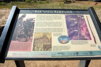
The Ancestral Puebloans were attracted to the mesa top by fertile soil, a relatively long growing season, and an ample amount of precipitation for “dryland” farming. In the form of winter snow and summer rainstorms, Mesa Verde averages about 17 inches of moisture per year.
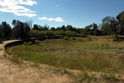
There is no evidence that agricultural fields within Mesa Verde were ever irrigated; however, the Ancestral Puebloans constructed an extensive network of ditches, canals, and reservoirs to collect and store rain water for domestic use.
(Left Photo Caption)
A Hopi farmer uses traditional techniques to grow corn. The introduction of corn, smaller and more drought-resistant than the kind we are familiar with today, changed the Ancestral Puebloans from nomadic hunter-gathers to settled farmers.
- Photo by A.C. Vroman, circa 1900s. Courtesy Seaver Center for Western History Research, Los Angeles County Museum of Natural History
(Center Map Caption)
In September 2004, Morefield, Box Elder, Far View, and Sagebrush reservoirs were designated as a National Historic Civil Engineering Landmark. This water management system is one of the oldest engineered public works in the United States.
- Map by National Park Service
(Center Photo Caption)
Corn requires 70 frost-free days to mature. The mesa top has an average of 85 frost-free days.
(Right Aerial Image Caption)
Aerial view of Chapin Mesa displaying the maize fields (near Far View Visitor Center) and a probable system of collector ditches and a canal ditch that carried water from the fields to Far View Reservoir.
- Aerial view courtesy of Bureau of Reclamation
(Right Photo Caption)
Digging stick used to loosen the soil before planting.
Erected by National Park Service.
Topics and series. This historical marker is listed in these topic lists: Agriculture • Native Americans • Settlements & Settlers. In addition, it is included in the ASCE Civil Engineering Landmarks series list. A significant historical month for this entry is September 2004.
Location. 37° 14.434′ N, 108° 30.278′ W. Marker is in Mesa Verde National Park, Colorado, in Montezuma County. Marker can be reached from State Highway 10, 1.3 miles south of Wetherill Mesa Road. Marker is located at the Far View Sites Complex in Mesa Verde National Park; the above directions are to the intersection of State Route 10 and the driveway to the Far View Sites parking area. Touch for map. Marker is in this post office area: Mesa Verde National Park CO 81330, United States of America. Touch for directions.
Other nearby markers. At least 8 other markers are within 6 miles of this marker, measured as the crow flies. Prehistoric Mesa Verde Reservoirs (here, next to this marker); A Monument to Time (approx. 2.8 miles away); Natural Seep Springs (approx. 2.8 miles away); Mesa Verde Administrative District (approx. 4 miles away); Montezuma Valley (approx. 5.2 miles away); Canyon Barriers (approx. 5.2 miles away); Knife Edge... (approx. 5.2 miles away); Fire Temple (approx. 5.4 miles away). Touch for a list and map of all markers in Mesa Verde National Park.
More about this marker. Marker and reservoir are located at the north end of the Far View Sites Complex; they may reached by a 1/4 mile trail from the parking area to the marker.
Also see . . . Mesa Verde National Park - Far View Sites. Official National Park Service website. (Submitted on February 21, 2014.)
Credits. This page was last revised on June 16, 2016. It was originally submitted on February 21, 2014, by Duane Hall of Abilene, Texas. This page has been viewed 683 times since then and 30 times this year. Photos: 1, 2, 3. submitted on February 21, 2014, by Duane Hall of Abilene, Texas.
Editor’s want-list for this marker. Photo of wide-view of marker and surroundings. • Can you help?


