Tappahannock in Essex County, Virginia — The American South (Mid-Atlantic)
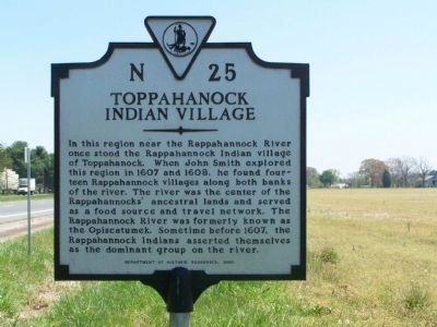
Toppahanock Indian Village
Erected 2000 by Department of Historic Resources. (Marker Number N-25.)
Topics and series. This historical marker is listed in these topic lists: Colonial Era • Exploration • Native Americans • Settlements & Settlers • Waterways & Vessels. In addition, it is included in the Virginia Department of Historic Resources (DHR) series list. A significant historical year for this entry is 1607.
Location. 37° 56.479′ N, 76° 52.341′ W. Marker is in Tappahannock, Virginia, in Essex County. Marker is on U.S. 17, 0.2 miles south of Daingerfield Road, on the right when traveling north. Touch for map. Marker is in this post office area: Tappahannock VA 22560, United States of America. Touch for directions.
Other nearby markers. At least 8 other markers are within one mile of this marker, measured as the crow flies. Hutchinson Tract (approx. half a mile away); Pollinators (approx. half a mile away); National Wildlife System (approx. half a mile away); Rivers of Grass (approx. 0.6 miles away); William Moore Tidewater Musician (approx. 0.9 miles away); Essex County Court House (approx. 1.1 miles away); 1728 Courthouse (approx. 1.1 miles away); British Raid on Tappahannock / The War of 1812 (approx. 1.1 miles away). Touch for a list and map of all markers in Tappahannock.
Also see . . . On the Road in Essex County - N-25-Toppahanock Indian Village. 2019 article by Zorine Shirley in the River Country News.Excerpt:
English Captain John Smith did arrive here, although as a prisoner at the time,because he was thought to have killed the Tribal Chief, some years earlier. He was found innocent and, as a cartographer, proceeded to chart the fourteen existing towns on the banks of the Rappahannock River.(Submitted on September 17, 2020.)
Credits. This page was last revised on September 17, 2020. It was originally submitted on April 27, 2008, by Bill Pfingsten of Bel Air, Maryland. This page has been viewed 1,887 times since then and 68 times this year. Photos: 1, 2. submitted on April 27, 2008, by Bill Pfingsten of Bel Air, Maryland.

