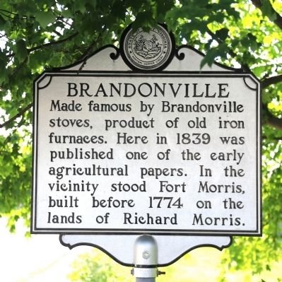
Brandonville in Preston County, West Virginia — The American South (Appalachia)
Brandonville
Topics and series. This historical marker is listed in these topic lists: Agriculture • Colonial Era • Industry & Commerce • Wars, US Indian. In addition, it is included in the West Virginia Archives and History series list. A significant historical year for this entry is 1839.
Location. 39° 39.958′ N, 79° 37.243′ W. Marker is in Brandonville, West Virginia, in Preston County. Marker is at the intersection of Main Street (West Virginia Route 26) and Church Street / Brandonville Pike (County Route 3), on the left when traveling north on Main Street. Touch for map. Marker is in this post office area: Bruceton Mills WV 26525, United States of America. Touch for directions.
Other nearby markers. At least 8 other markers are within 7 miles of this marker, measured as the crow flies. Brandonville Community Honor Roll (here, next to this marker); Hagans Homestead (about 600 feet away, measured in a direct line); Bruceton (approx. one mile away); Kay Evans (approx. 1.2 miles away); Bruceton Community Honor Roll (approx. 1.3 miles away); Old Hemlock (approx. 1.3 miles away); Honor Roll (approx. 3.9 miles away); Mt. Moriah Cemetery Veterans (approx. 6.3 miles away). Touch for a list and map of all markers in Brandonville.
Credits. This page was last revised on November 2, 2017. It was originally submitted on June 17, 2014, by J. J. Prats of Powell, Ohio. This page has been viewed 608 times since then and 51 times this year. Photos: 1, 2. submitted on June 17, 2014, by J. J. Prats of Powell, Ohio. 3. submitted on October 24, 2017, by Tom Bosse of Jefferson City, Tennessee.


