Near Beckley in Raleigh County, West Virginia — The American South (Appalachia)
From Agriculture to Mining
Shortly after European explorers arrived, permanent settlers began to use the "Indian Path" to enter southern West Virginia. The first permanent settlers arrived at Paint Creek in the early 19th century. Agriculture was the dominant way of life for those first settlers who called these rugged mountains home. Some farmers became very successful farmers with large landholdings; however, most farmers struggled to sustain their families on a rough subsistence lifestyle. The pastoral charm of the more successful farming communities can still be seen today along Paint Creek in the communities of Sweeneyburg, Maynor, Cirtsville, and Lively.
When railroads arrived and opened the door to vast coal deposits, many farmers gave up the plow to work in the mines. Only the most successful farmers retained an agricultural lifestyle, and these farmers enjoyed a relatively affluent lifestyle compared to the miners in the coal camps. While mining was not easy work, the steady income and access to company stores made the tradeoff worthwhile for many. Within a short period of time, Paint Creek transformed from a land of scattered farms and homesteads to a land bustling with coal camps and the sound of steam engines.
The shift from agriculture to mining did not remove agriculture from the blood of the miners. Immigrant miners, many of whom had been farmers in their home lands, brought agricultural skills with them. Gardens became a common sight in the coal camps. Because miners' wives did not have any other local industry available to them, they often tended gardens and kept animals with the help of their children. Gardening provided a safeguard against inconsistent employment, economic depressions, and strikes that frequently swept the coalfields. Gardening also helped minters reduce their dependency on company stores and avoid debt. Some miners used the bounty of their gardens to produce homebrew which they sold for supplemental income.
The Paint Creek Scenic Trail is included within the National Coal Heritage Area. Funding for this project was provided in part by the Beckley Area Foundation and The Federal Highway Administration.
[Photo captions, from top left around to top right, read]
1. Carl Pittman navigates a horse-drawn cart in Maple Fork. This area of upper Paint Creek in Raleigh County has been a predominately agricultural area since the time of settlement.
Photo courtesy of Max Tyree
2. Mr. Lively stands on his farm in Lively just to the north of Pax. Mr. Lively, first name unknown, is a descendent of the Lively family that first settled this area in 1844.
Photo courtesy of Don Davis
3. Each Friday, or "mill day", farmers from around the region brought their grain to Asa Spangler's Mill in Cirtsville for grinding.
Photo courtesy of Don Davis
4. The Virginian Railway crosses a trestle in Sweeneyburg. The Virginian Railway arrived in this area in 1906 and offered access to the Atlantic coast at Hampton Roads, VA.
Photo courtesy of Homer Aliff
5. Patrons enjoy some drinks outside the Needmore Saloon in the early 1900s. Because Raleigh County did not permit the sale of alcohol, the saloon was built just across the county line in Fayette County.
Photo courtesy of Don Davis
6. This impressive trestle is found along the Paint Creek Scenic Trail in Sweeneyburg. The trestle is about 200 ft. tall and 500 ft. long, and was originally constructed by the Virginian Railway.
Photo courtesy of Ronn Raszetnik
————————————
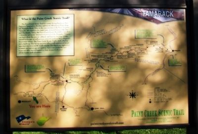
What is the Paint Creek Scenic Trail?
The Paint Creek Scenic Trail is a scenic byway/backway that begins at Tamarack in Beckley and travels 44 miles to Pratt along the Kanawha River. Prior to the construction of the West Virginia Turnpike, this road was the main route of travel between Beckely and Charleston. Today, the Paint Creek Scenic Trail offers travelers a leisurely and scenic alternative to travel on the Turnpike. Visitors can learn about the natural, cultural, and historic heritage of this storied landscape, as well as enjoy some of southern West Virginia's finest trout fishing. Two byway sections offer a well-maintained single lane road that is accessible to all vehicles. One backway segment is a remote and narrow paved roadway that is unsuitable for tour buses and RVs, but will appeal to those in search of a true off-the-beaten-path adventure.
Erected by Paint Creek Scenic Trail and America's Byways.
Topics. This historical marker is listed in these topic lists: Agriculture • Environment • Industry & Commerce • Settlements & Settlers. A significant historical year for this entry is 1844.
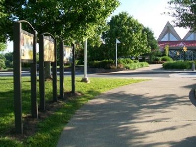
Location. 37° 48.117′ N, 81° 12.986′ W. Marker is near Beckley, West Virginia, in Raleigh County. Markers are at Tamarack, the West Virginia cultural heritage and artisan center. Tamarack is accessed from I-77 Exit 45. Touch for map. Marker is at or near this postal address: One Tamarack Park, Beckley WV 25801, United States of America. Touch for directions.
Other nearby markers. At least 8 other markers are within 2 miles of this marker, measured as the crow flies. The Indian Path (here, next to this marker); Mortality (within shouting distance of this marker); Dinky Locomotive (approx. 1.6 miles away); Raleigh County Coal Mines (approx. 1.6 miles away); Bachelor’s Shanty (approx. 1.6 miles away); Superintendent's House (approx. 1.7 miles away); Samuel B. Antonio (approx. 1.9 miles away); Cleared for Takeoff (approx. 1.9 miles away). Touch for a list and map of all markers in Beckley.
Also see . . .
1. National Coal Heritage Area. Website homepage (Submitted on July 6, 2014, by William Fischer, Jr. of Scranton, Pennsylvania.)
2. Paint Creek Scenic Trail Driving Tour. Website homepage (Submitted on July 7, 2014, by William Fischer, Jr. of Scranton, Pennsylvania.)
3. Tamarack Marketplace. Website homepage (Submitted on July 7, 2014, by William Fischer, Jr. of Scranton, Pennsylvania.)
Credits. This page was last revised on January 22, 2022. It was originally submitted on July 6, 2014, by William Fischer, Jr. of Scranton, Pennsylvania. This page has been viewed 639 times since then and 47 times this year. Photos: 1, 2, 3. submitted on July 7, 2014, by William Fischer, Jr. of Scranton, Pennsylvania.


