
Cookeville in Putnam County, Tennessee — The American South (East South Central)
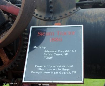
Steam Tractor 1886
Photographed by Deanna Lack, July 10, 2014
1. Steam Tractor 1886 Marker
Battle Creek, MI
#212F
Powered by wood or coal
13hp, runs up to 5 mph
Brought here from Gallatin, TN
Topics. This historical marker is listed in these topic lists: Agriculture • Roads & Vehicles.
Location. 36° 7.819′ N, 85° 28.785′ W. Marker is in Cookeville, Tennessee, in Putnam County. It is on Salem Road, on the right when traveling north. Touch for map. Marker is at or near this postal address: 1750 Salem Road Cookeville TN 38501, Cookeville TN 38501, United States of America. Touch for directions.

Regionally, this marker is in the American South, specifically in the Upper South, in Appalachia, and specifically in Southern Appalachia. Globally, it is in North America, the Western Hemisphere, the Western World, and the Anglosphere. Historically, it finds itself in what was once the territory of the Mississippian Culture, one of the Confederate States of America, and the Antebellum South.
Other nearby markers. At least 8 other markers are within 3 miles of this marker, measured as the crow flies: Old Salem Methodist Church
this page online

Photographed by Deanna Lack, July 10, 2014
2. Steam Tractor 1886 Marker
Credits. This page was last revised on June 16, 2016. It was originally submitted on July 11, 2014, by Deanna Lack of Sparta, Tennessee. This page has been viewed 753 times since then and 37 times this year. Photos: 1, 2. submitted on July 11, 2014, by Deanna Lack of Sparta, Tennessee. • Bill Pfingsten was the editor who published this page.
