Ogdensburg in St. Lawrence County, New York — The American Northeast (Mid-Atlantic)
Fort de la Présentation - 1749-1759
A French Foothold on the South Bank
— French & Indian War —
A Mission/Supply Base
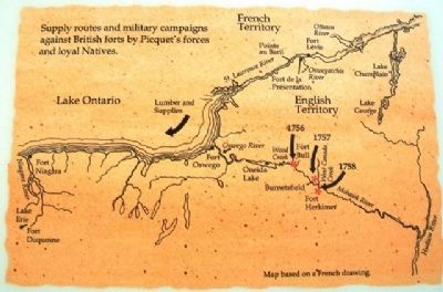
Fort de la Présentation, used as a fortified mission by Father Abbé François Picquet, was built at the mouth of the Oswegatchie River in 1749 and 1750. Picquet intended to Christianize much of the native population, make them French allies, and convince them to attack the English settlements to the south on the Mohawk River, and to the west at Oswego. Picquet accompanied them on numerous occasions. Captain de Lery's winter raid on Fort Bull on the Oneida Carry in 1756, Captain de Belletre's successful attack on Burnetsfield (Herkimer) in the fall of 1757, and the surprise raid on Fort Herkimer in April of 1758 are but a few of them.
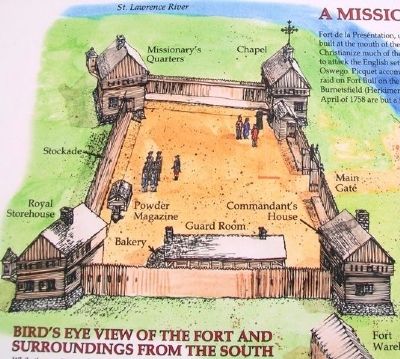
Bird's Eye View of the Fort and Surroundings from the South
While the garrison at the fort remained small, two dozen or so men, Picquet's parish included 3,000 people on both sides of the river.
Abbé François Picquet 1708-1781
Father Picquet was a Sulpician priest who came to Montreal from France in 1734. He spent several years studying Indian languages and customs and serving the local native parish. He served at the Sulpician Mission at Lake of Two Mountains (Oka) from 1739-1749 where he decided to work with the American Indians south of the Great Lakes for conversion and to secure their loyalty to France. He encouraged his followers to attack English settlements, and to raise crops and farm animals to be sent to French forts in the interior, along with native made clothing and equipment.
After Fort Niagara fell in 1759 Picquet abandoned Fort de la Présentation, relocating his mission on Isle Péquétou de Gal (Galop Island). When British allied American Indians burned that mission in 1760, Picquet fled to Montreal, then to New Orleans, eventually returning to France in 1772.
Strategic Role
Fort de la Présentation became an important supply base to western French forts at Niagara on Lake Ontario and Duquesne in western Pennsylvania. Native made snowshoes, toboggans and clothing, along with native grown fruits, vegetables, dried fish, meat and bread from the fort's oven were constantly shipped from the warehouses of Fort de la Présentation into the interior. Lumber from the fort's sawmill was shipped to the boat building facility at Pointe au Baril located on the St. Lawrence River to the west.
Erected by Se.
Topics and series. This historical marker is listed in these topic lists: Forts and Castles • Man-Made Features • Native Americans • Settlements & Settlers. In addition, it is included in the Great Lakes Seaway Trail National Scenic Byway series list. A significant historical month for this entry is April 1758.
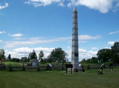
Location. 44° 41.667′ N, 75° 30.073′ W. Marker is in Ogdensburg, New York, in St. Lawrence County. Marker is on the Downtown Arterial (New York State Route 68) west of Commerce Street, on the right when traveling west. Touch for map. Marker is in this post office area: Ogdensburg NY 13669, United States of America. Touch for directions.
Other nearby markers. At least 8 other markers are within walking distance of this marker. Fort la Présentation (here, next to this marker); Fort Lévis - 1760 (here, next to this marker); Fort Oswegatchie 1760-1796 (here, next to this marker); The Battle of Ogdensburg (here, next to this marker); Aka Se We':Ka Tsi (Oswegatchie) (here, next to this marker); Fort de la Présentation (here, next to this marker); Abbe Picquet 1708 -1781 (about 400 feet away, measured in a direct line); Mission Fort (about 500 feet away). Touch for a list and map of all markers in Ogdensburg.
Also see . . . Fort la Présentation. New York State Military Museum entry (Submitted on July 29, 2014, by William Fischer, Jr. of Scranton, Pennsylvania.)

Photographed By Larry Gertner, May 15, 2021
6. Fort de la Présentation
Museum website homepage
Click for more information.
Click for more information.
Credits. This page was last revised on May 24, 2021. It was originally submitted on July 29, 2014, by William Fischer, Jr. of Scranton, Pennsylvania. This page has been viewed 560 times since then and 40 times this year. Photos: 1, 2, 3. submitted on July 29, 2014, by William Fischer, Jr. of Scranton, Pennsylvania. 4. submitted on July 28, 2014, by William Fischer, Jr. of Scranton, Pennsylvania. 5. submitted on July 29, 2014, by William Fischer, Jr. of Scranton, Pennsylvania. 6. submitted on May 24, 2021, by Larry Gertner of New York, New York.


