Stigler in Haskell County, Oklahoma — The American South (West South Central)
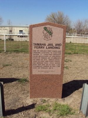
Tamaha Jail and Ferry Landing
Erected 1995 by Oklahoma Historical Society. (Marker Number 70.)
Topics and series. This historical marker is listed in these topic lists: Industry & Commerce • Native Americans • Settlements & Settlers • Waterways & Vessels. In addition, it is included in the Oklahoma Historical Society series list. A significant historical year for this entry is 1831.
Location. 35° 15.654′ N, 95° 3.754′ W. Marker is in Stigler, Oklahoma, in Haskell County. Marker is at the intersection of State Highway 9 and Tamaha Road, on the right when traveling west on State Highway 9. Touch for map. Marker is in this post office area: Stigler OK 74462, United States of America. Touch for directions.
Other nearby markers. At least 5 other markers are within 11 miles of this marker, measured as the crow flies. Battle of the J.R. Williams (here, next to this marker); In Memory of the Early Choctaw Settlers (approx. 3˝ miles away); Haskell County World War Memorial (approx. 3˝ miles away); Unmarked Settlers' Graves Monument (approx. 3˝ miles away); a different marker also named Tamaha Jail and Ferry Landing (approx. 10˝ miles away).
Regarding Tamaha Jail and Ferry Landing. Actual town of Tamaha is approximately 10 miles NNW of marker location.
Related marker. Click here for another marker that is related to this marker.
Credits. This page was last revised on November 7, 2023. It was originally submitted on August 22, 2014, by Michael Manning of Woodlawn, Tennessee. This page has been viewed 487 times since then and 31 times this year. Photo 1. submitted on August 22, 2014, by Michael Manning of Woodlawn, Tennessee. • Bernard Fisher was the editor who published this page.
Editor’s want-list for this marker. A wide shot of the marker and its surroundings. • Can you help?
