Lunenburg in Lunenburg County, Nova Scotia — The Atlantic Provinces (North America)
Merligueche

Photographed By Barry Swackhamer, June 16, 2014
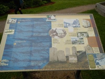
1. Merligueche Marker
Captions (English / French): (left side, top to bottom) Modern recreation of Mi’kmaq fish drying methods. / Reconstruction moderne des méthodes de sécher des poisson employées par les Mi’kmaq.; Mi’kmaq canoe / Canoe mi’kmaq; (left side, clockwise from the top) Census, 1708 / Recensement, 1708; Stone dated 1754 in Old French Cemetery. / Pierre de vieux cimetière française remontant à 1754; Acadian kitchen, modern illustration. / Cuisine acadienne, illustration moderne.; Acadians trades with New England merchants. / Les Acadiens fraisaient du commerce avec la Nouvelle-Angleterre.; Acadian farmhouse, modern illustration. / Maison de ferme acadienne, illustration moderne.; Early Mi’kmaq encampment. / Ancien campement mi’kmaq.
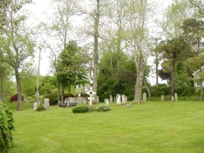
This site known as the Old French Cemetery, is one of the few links to the Town’s Mi’kmaq and Acadian past. Known by the Mi’kmaq as Merligueche meaning whitecaps which topped the waves in the harbour, the name continued to be used by the French in the 17th and 18th centuries. Before the arrival of the French, the Mi’kmaq likely hunted food, fished and harvested wild berries in the area. The 1604 explorations of the south coast of what is now Nova Scotia by French explorers Sieur de Monts and Samuel de Champlain led to trading contacts with the Mi’kmaq and an interest in this land, rich in fish and furs. In 1632, Isaac de Razilly established Fort Sainte Marie-de-Grâce at the mouth of the LaHave River to trade with the Mi’kmaq. Nicholas Denys soon set ups a lumbering operation in the rich oak forests between LaHave and Merligueche. The 17th century struggle between France and England to control Acadia resulted in only sporadic attempts to settle the area around Meligueche, a centre of trade between the French and the Mi’kmaq.
Between 1708 and 1748, the Acadian population of the area grew from two to 15 families trading with the Mi’kmaq for furs and berries and growing crops in the area know known as Garden Lots. In 1749, Colonel Edward Cornwallis wrote of Merlingueche: “The families… there have very comfortable wooden houses covered with bark, and good many Cattle and Sheep, and clear ground more than serves themselves.” By 1753, only one Acadian or Mi’kmaq family remained, that of Paul Labrador, a descendant of Claude Guédry an early 18th century settler. In 1755 nearly 10,000 Acadians were deported from Nova Scotia by the British government because of their refusal to swear allegiance to the British Crown.
After the departure of the Acadians, where did the next settlers to speak French in Lunenburg come from?
French
Le vieux cimetière français est l’un des seuls liens qui rappellent encoure à la ville ses antécédents mi’kmaq et acadiens. Les Mi’kmaq appelaient la ville Merligueche, qui veut dire le moutonnement que font les vagues dans la port. Les Français ont continué d’appeler l’emplacement par ce nom aux 17ᵉ et 18ᵉ siècle. Avant l’arrivée des Français, les Mi’kmaq devaient sans doute chasser, pêcher et cueiller les baies de la région. Les excursions de 1604 sur la côte sud de la Nouvelle-Écosse actuelle par des explorateurs français, le sieur de Monts et Samuel de Champlain, mènent à l’établissement de liens commerciaux avec les Mi’kmaq et à un intérêt dans cette terre riche en poisson et en fourrures. En 1632, Isaac de Razilly établit le fort Sainte Marie-de-Grâce à l’embouchure de la rivière LaHave pour le commerce avec les Mi’kmaq. Nicolas Denys commence peu après à exploiter les riches forêts de chêne qui s’étendent entre LaHave et Merligueche. Compte tenu de la lutte que se font la France et L’Angleterre pour conquérir l’Acadie, au 17ᵉ siècle, il n’y a que des tentatives sporadiques en vue de coloniser la région de Merligueche, centre de commerce entre les Français et les Mi’kmaq.
Entre 1708 et 1748, la population acadienne de la région passe de deux à quinze familles. Ces Acadiens font la traite de fourrures et de baies avec les Mi’kmaq et pratiquent l’agriculture dans le secteur aujourd’hui appelé «Garden Lots». En 1749, le colonel Edward Cornwallis écrit de Merligueche que les families qui y vivent ont de très comfortables maisons en bois recouvertes d’écorce, de nombreux moutons et têtes de bétail et plus terres défrichées qu’elles en ont besoin. En 1753, il ne reste plus qu’une seul famille parmi les Acadiens et les Mi’kmaq, soit celle de Paul Labrador, descendant de Claude Guédry, colon de début de 18ᵉ siècle. En 1755, près de 10 000 Acadiens son déportés de la Nouvelle-Écosse par le gouvernement britannique à cause de leur refus de prêter le serment d’allégeance à la Couronne britannique.
D’où sont venus les primaires colons d’expression française qui se sont établis à Lunenburg après le départ des Acadiens?
Erected by Town of Lunenburg.
Topics and series. This historical marker is listed in these topic lists: Exploration • Native Americans • Settlements & Settlers • War, French and Indian. In addition, it is included in the Acadian History series list. A significant historical year for this entry is 1604.
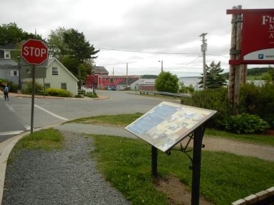
Location. 44° 22.602′ N, 64° 18.839′ W. Marker is in Lunenburg, Nova Scotia, in Lunenburg County. Marker is at the intersection of Linden Avenue and Bluenose Drive, on the left when traveling west on Linden Avenue. Touch for map. Marker is at or near this postal address: 34 Linden Avenue, Lunenburg NS B0J 2C0, Canada. Touch for directions.
Other nearby markers. At least 8 other markers are within walking distance of this marker. The Early Acadian History of Lunenburg (a few steps from this marker); Foreign Protestant Settlement in Lunenburg (within shouting distance of this marker); First Peoples (within shouting distance of this marker); Lunenburg’s Fishing Industry to the 1870’s (about 120 meters away, measured in a direct line); Old Town Lunenburg Historic District (about 210 meters away); St. John's Anglican Church / L'église anglicane St. John's (about 210 meters away); Lunenburg’s Fishing Industry 1870’s - 1940’s (about 210 meters away); St. John's Parish Hall (about 240 meters away). Touch for a list and map of all markers in Lunenburg.
Additional keywords. Acadians
Credits. This page was last revised on June 16, 2016. It was originally submitted on October 24, 2014, by Barry Swackhamer of Brentwood, California. This page has been viewed 1,721 times since then and 157 times this year. Photos: 1, 2, 3. submitted on October 24, 2014, by Barry Swackhamer of Brentwood, California. • Andrew Ruppenstein was the editor who published this page.

