Annapolis Royal in Annapolis County, Nova Scotia — The Atlantic Provinces (North America)
Annapolis Royal Historic District
L’arrondissement historique d’Annapolis Royal
Photographed by Barry Swackhamer, June 17, 2014
1. Annapolis Royal Historic District Marker

English
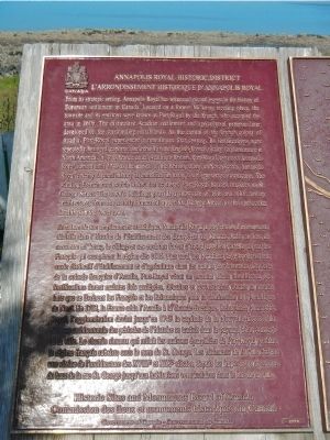
From its strategic setting, Annapolis Royal has witnessed pivotal events in the history of European settlement in Canada. Located on a former Mi’kmaq meeting place, the townsite and its environs were known as Port-Royal by the French, who occupied the area in 1605. The distinctive Acadian settlement and agricultural patterns later developed on the surrounding marshlands. As the capital of the French colony of Acadia, Port-Royal experienced a tumultuous first century. Its fortifications were repeatedly besieged, captured and rebuilt in the English-French rivalry for dominance in North America. In 1713 France ceded Acadia to Britain. Port-Royal, renamed Annapolis Royal, served until 1749 as the capital of the British colony of Nova Scotia. Annapolis Royal’s richly layered history is embodied in today’s well-preserved townscape. The winding French road which linked the scattered Port-Royal houses survives as St. George Street. The town buildings provide a showcase of 18th and 19th century architecture, from the stately homes of upper St. George Street to the vernacular dwellings of the lower town.
French
this page online
Photographed by Barry Swackhamer, June 17, 2014
2. Annapolis Royal Historic District Marker
Click on this image to enlarge it.
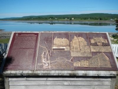
Captions (English / French): (clockwise from the center, top) DeGannes - Cosby House, circa 1708. / Maison DeGannes - Cosby, vers 1708.; Old Post Office, circa 1889. / Ancien bureau de poste, vers 1889.; Runciman House, circa 1817. / Maison Runciman, vers. 1817.; Historic streetscape - Lower St. George Street (Bailey House, Robertson Houe, Bonnett House, Murray House), circa 1755-1790. / (no French).; • The dot indicates heritage buildings and site within the historic zone. / • Les points désignent les bâtiments et lieux patrimoniaux situés dans l’arrondissement historique.
Captions (English / French): (clockwise from the center, top) DeGannes - Cosby House, circa 1708. / Maison DeGannes - Cosby, vers 1708.; Old Post Office, circa 1889. / Ancien bureau de poste, vers 1889.; Runciman House, circa 1817. / Maison Runciman, vers. 1817.; Historic streetscape - Lower St. George Street (Bailey House, Robertson Houe, Bonnett House, Murray House), circa 1755-1790. / (no French).; • The dot indicates heritage buildings and site within the historic zone. / • Les points désignent les bâtiments et lieux patrimoniaux situés dans l’arrondissement historique.
Erected 1998 by Historic Sites and Monument Board of Canada/Commission de lieux et monuments historique du Canada.
Topics and series. This historical marker is listed in these topic lists: Colonial Era • Indigenous Peoples and Communities • Settlements & Settlers. In addition, it is included in the Acadian History, and the Canada, Historic Sites and Monuments Board series lists. A significant historical year for this entry is 1605.
Location. 44° 44.607′ N, 65° 31.193′ W. Marker is in Annapolis Royal, Nova Scotia, in Annapolis County. It is on St. George Street close to St. James Street, on the left when traveling north. Touch for map. Marker is at or near this postal address: 253 St George Street8, Annapolis Royal NS B0S 1A0, Canada. Touch for directions.

Regionally, this marker is on the Evangeline Trail. It is also in the Maritimes and in Atlantic Canada. Globally, it is in the North Atlantic Region, North America, the Western Hemisphere, the
circa 1905
3. Post Office, Annapolis Royal, N.S.
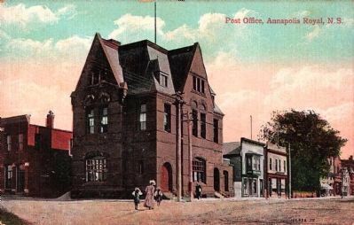
This is the top middle building depicted in relief on the marker.
Other nearby markers. At least 8 other markers are within walking distance of this marker: Rose Fortune (a few steps from this marker); Masonic Stone of 1606 (within shouting distance of this marker); Sir William Robert Wolseley Winniett. (within shouting distance of this marker); Sir William Fenwick Williams (within shouting distance of this marker); William Wolseley (about 120 meters away, measured in a direct line); Sieur de Monts (about 120 meters away); Major Erasmus James Philipps (about 120 meters away); Sinclair Inn (about 120 meters away). Touch for a list and map of all markers in Annapolis Royal.
Photographed by Barry Swackhamer, June 17, 2014
4. Annapolis Royal Historic District Marker
Credits. This page was last revised on March 15, 2025. It was originally submitted on November 6, 2014, by Barry Swackhamer of Brentwood, California. This page has been viewed 786 times since then and 37 times this year. Photos: 1, 2. submitted on November 6, 2014, by Barry Swackhamer of Brentwood, California. 3. submitted on November 7, 2014. 4. submitted on November 6, 2014, by Barry Swackhamer of Brentwood, California. • Andrew Ruppenstein was the editor who published this page.
