John Dickinson Plantation near Dover in Kent County, Delaware — The American Northeast (Mid-Atlantic)
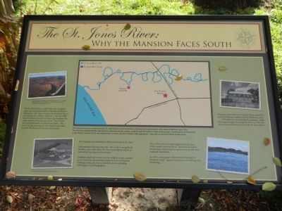
The St. Jones River: Why the Mansion Faces South
Inscription.
The St. Jones River, a major Delaware navigable waterway, is situated south of the John Dickinson Plantation. The river connects the Delaware Bay to the inland city of Dover. Between 1760 and 1808, John Dickinson owned six farms that bordered the north shores of the St. Jones River. These farms were approximately six miles from Dover. The river was the main source of transportation used by John Dickinson, his family, and tenants.
The mansion was situated just 300 yards north of the river. Early property descriptions note, "The Creek is navigable for Shallops, some miles above the Farms and affords at least six convenient Landings on the premises."
Shallops, small open boats used in shallow waters, carried grain and other agricultural products from Dickinson's landings along the river to northern ports including Wilmington and Philadelphia.
The St. Jones River helped supplement the diet of the people on Jones Neck. Residents included landowners, indentured servants, tenants, free and enslaved individuals.
In 1764, a newspaper advertisement leasing the property noted "... great Conveniency for fishing and Oystering..."
Topics. This historical marker is listed in these topic lists: Agriculture • Colonial Era • Horticulture & Forestry • Settlements & Settlers. A significant historical year for this entry is 1760.
Location. 39° 6.045′ N, 75° 26.9′ W. Marker is near Dover, Delaware, in Kent County. It is in John Dickinson Plantation. Marker can be reached from Kitts Hummock Road. Located on the John Dickinson Plantation. Touch for map. Marker is in this post office area: Dover DE 19901, United States of America. Touch for directions.
Other nearby markers. At least 8 other markers are within 2 miles of this marker, measured as the crow flies. Home of John Dickinson (approx. ¼ mile away); St. Jones Neck (approx. 0.4 miles away); Byfield (approx. 1.2 miles away); C-45G (approx. 1.2 miles away); C-60 (approx. 1.2 miles away); U-3A (approx. 1.2 miles away); LGM-30 (approx. 1.2 miles away); C-5A (approx. 1.2 miles away). Touch for a list and map of all markers in Dover.
Credits. This page was last revised on September 17, 2023. It was originally submitted on November 26, 2014, by Nathan Davidson of Salisbury, Maryland. This page has been viewed 663 times since then and 48 times this year. Photos: 1, 2, 3. submitted on November 26, 2014, by Nathan Davidson of Salisbury, Maryland. • Bill Pfingsten was the editor who published this page.


